Teacha
  • Courses
  • Mock Exams
  • For Tutors
  • For Schools
  • Pricing
Log InStart Free
  1. Past Questions
  2. /
  3. JAMB
  4. /
  5. Geography
  6. /
  7. 1979
  8. /
  9. Q0
Question 0Question image

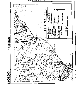
The true bearing of the trigonometrical station 54.0m from the peak of Bedi Hill is

  • A.127°
  • B.200°
  • C.233°
  • D.266°
  • E.319°
Objective

Question details

Exam body
JAMB
Subject
Geography
Year
1979
Question no.
#0
Type
Objective
Previous · Q0The elevated feature that runs westwards from the cape near Mito to the western… Next · Q0 The appropriate geographical term for that narrow feature east of Ela Lagoon…

More from this paper

  • Q0What is the length to the nearest kilometer of the main stream that flows into…
  • Q0What is the approximate height of Manko above the sea level?
  • Q0Which of the following scales should show the greatest amount of detail on a…
  • Q0Rotation of the earth is
  • Q0The direct cause of waves is
  • Q0Which of the following is not a form of precipitation?
See all Geography 1979 questions
Teacha

Africa's learning & exam readiness platform. Built for students, tutors, and schools.

Platform

  • Courses
  • Mock Exams
  • Past Questions

For You

  • I'm a Tutor
  • I'm a School
  • Pricing

© 2025 Teacha. Built for African learners, tutors, and schools. Teacha is not affiliated with WAEC, NECO, or JAMB. All past questions are sourced from publicly available materials.

Privacy PolicyTerms of UseCookie Policy