Question 0In which one of the following sections of a hill slope would you expect the soil to be deepest and most moist? TheA.footslopeB.midslopeC.summitD.upper slopeE.fall slopeObjective Show full explanation
Question 0A volcanic eruption is most likely to be violet when?A.volcano is near the seaB.neck of the volcano is sealed by a plugC.lava is viscousD.lava reaches the surface through a fissureE.volcano is below an oceanObjective Show full explanation
Question 0Poorly drained soils are good for the growth of?A.oil palmB.surgarcaneC.cocoaD.riceE.maizeObjective Show full explanation
Question 0Which of the following factors CANNOT be used to explain the nature and pattern of distribution of savannah vegetation in Africa?A.grazingB.bush burningC.crop cultivationD.seasonal rainfallE.temperatureObjective Show full explanation
Question 0Which of these is NOT a weathering process?A.The removal of regolith under the influence of weatherB.The alteration of calcium carbonate in rocks to calcium bicarbonateC.The breakdown of rocks by plant rootsD.The formation of clay minerals from feldspars in granitesE.The disintergration of rocks by freeze-and-thaw actionObjective Show full explanation
Question 0A map measures 10cm by 6cm.If the map is enlarge such that its area is 240 sq. cm, the map is enlarged?A.twiceB.thriceC.four timesD.five timesE.six timesObjective Show full explanation
Question 0Which of the following statements is true of the Sahara Desert, the Arctic and sub-Arctic regions of North America?A.The areas inhabited by primitive hunters and tradersB.These areas have the world's largest known deposits of crude oilC.population is found in isolated oases and along the river valley'sD.The enviroment is very harsh for both man and animalE.The inhabitants belong to the oldest races in the worldObjective Show full explanation
Question 0The major mountain belts of the world were produced through?A.wind erosionB.glacial activityC.volcanic activityD.foldingE.river depositionObjective Show full explanation
Question 0Which of the following statements bests describes the weathering process known as exfoliation?A.The chemical alteration of rock minerals on taking in waterB.The peeling away of rocks in thin layers acidC.The dissolution of basic minerals by carbonic acidD.The addition of oxygen to mineral elements to form oxidesE.The disintegration of foliated rocksObjective Show full explanation
Question 0Which of the instruments is used in measuring wind speed?A.Wind vaneB.BarometerC.Cup anamometerD.HygrometerE.SpeedometerObjective Show full explanation
Question 0Which of the following features is NOT commonly associated with a river at the floodplain stage?A.Ox-bow lakesB.MeandersC.LeveesD.KnickpointE.Braided channelObjective Show full explanation
Question 0The 'Mediterranean type' of climate refers to?A.short wet summer, dry winter, mean temperature above 20°C and precipitation about 1,000 mm per yearB.wet winter, dry summer, temperature varies from about 6°C in winter to about 20°C in summer and precipitation ranges between 700 and 1,000mm per yearC.short wet summer, prolonged dry winter and percipitation is about 500 mm per yearD.dry and wet climate; temperature around 20°C and percipitation ranges between 1,000 and 2,000 mm per yearE.precipitation all the year round (about1,000 mm per year) with a peak in with warm summer (20-26°C) and mild winter (6-10°C)Objective Show full explanation
Question 0A river deposits its load of sediment if the?A.quantity of water in the river increasesB.river flows from a mountain area onto a plainC.river enters a gorgeD.velocity of the river increasesE.river approaches as waterfallObjective Show full explanation
Question 0In which vegetation zone is Abuja, the new Federal Capital, location?A.Southern Guinea savannahB.Sahel savannahC.Northern Guinea savannahD.Tropical rain forestE.Montane grasslandObjective Show full explanation
Question 0Which of these statements is NOT true of the great circle?A.The equator is a great circleB.The great circle is the largest circle one can draw on a sphereC.The great circle is the path of the shortest distance over the earth's surface between two pointsD.Each meridian is a great circleE.All great circles bisect the earthObjective Show full explanation
Question 0Which of these best explains the rapid rise in world population during the twentieth century?A.Large-scale migration of peopleB.Decline in death ratesC.Increase in world food productionD.Improvement in transportation which enables food to be moved from surplus to deficit areasE.Rapid rate of urbanizationObjective Show full explanation
Question 0Which of the following areas is subject to frequent earthquarkes?A.The Canandian ShieldB.Northern AustraliaC.North West AfricaD.South AfricaE.The Sahara DesertObjective Show full explanation
Question 0Within the last few years Alaska, Mexico and the North Sea have become important in the production of?A.coalB.petroleumC.phosphateD.goldE.uraniumObjective Show full explanation
Question 0The direct flight from town X on longitude 42°30'E to town Y on longitude 5°E takes 4(1/2) hours. If an aeroplane leaves town X at 10.00 a.m local time, what will be the local time in town Y when it arrives there?A.2.30 p.mB.10.00 a.mC.12 noonD.7.30 a.mE.2.00 p.mObjective Show full explanation
Question 0Examples of folded structures in Africa include the Atlas Mountains, the Cape Rangers and the?A.Akwapim HillsB.Jos PlateauC.RuwenzoriD.East Africa RiftE.Adamawa HighlandsObjective Show full explanation
Question 0How is the mean annual rainfall of a given place calculated using records for 35 years?A.by summing the yearly average rainfall figure and dividing by 35B.by summing the yearly total rainfall figures dividing by 35C.by summing the yearly total rainfall figures for 35 years and dividing by 12D.by finding the average between the figures for the wettest and the the direst years and multiplying by 35E.by plotting the rainfall figures on a graph and finding the midpointObjective Show full explanation
Question 0The three leading manufacturing countries of the world are?A.Japan, USA and ItalyB.USA, Britain and Hong KongC.Japan, Western Germany and BritainD.China, Japan and BrazilE.Japan, USA and Western GermanyObjective Show full explanation
Question 0Ivory Coast has become famous in recent years for its modern agricultural development projects especially in respect of?A.poultry farming and cattle ranchingB.cocoa and fruit growingC.fish and poultryD.oil palm and vegetable growingE.fruit and flower growingObjective Show full explanation
Question 0In which of the following vegetation types do you expect to find reindeer?A.MediterraneanB.Temperate evergreenC.TundraD.Tropical monsoonE.Temperate grasslandObjective Show full explanation
Question 0Which ONE of the following regions has the world's largest potential water power resources, but has the least developed water power?A.AfricaB.CanadaC.south AmericaD.ScandinaviaE.AustraliaObjective Show full explanation
Question 0Which of the following is the main export from Uganda?A.JuteB.BannanaC.TobaccoD.SisalE.CoffeeObjective Show full explanation
Question 0Tropical cyclones arise in the belts of the?A.doldrumsB.westerliesC.trade windsD.polar windsE.monsoon windsObjective Show full explanation
Question 0The dominant pattern pattern of seasonal labour migration in West Africa is form?A.the interior to the coastal beltB.the coastal belt to the interiorC.east to westD.west to eastE.the middle belt to the north and southObjective Show full explanation
Question 0Which of the following factors best accounts for the sparse population of the interior parts of Kenya and Tanzania?A.very high wildlife populationB.the rift valleys are rugged and uninhabitableC.the people are nomadsD.the soil and climatic conditions are unfavorableE.many hectares of land are under reserveObjective Show full explanation
Question 0The two major air masses affecting the climate of West Africa are the?A.harmattan wind and the south-west monsoonB.south-west monsoon and the troppical martimeC.tropical continental and the tropical maritimeD.tropical continental and south-west monsoonE.warm equatorial and the tropical maritimeObjective Show full explanation
Question 0Which of the following shipping routes carries the world's heaviest ocean traffic?A.Mediterranean - Suez Canal - Indian OceanB.Western Europe - CaribbeanC.Eastern North America - Western EuropeD.West Coast United States - Panama CanalE.Western Europe - southern Africa - AustraliaObjective Show full explanation
Question 0Which of these three west Africa countries have economic deposit of iron ore?A.Nigeria, Mali and Upper VoltaB.Niger, Mali and MauritaniaC.Nigeria, Guinea and Sierral LeoneD.Mali, Sengal and Sierra LeoneE.Liberia Sierra Leone and TogoObjective Show full explanation
Question 0Which of these best accounts for the decline in railway transport in Nigeria in the last two decades?A.Competition from air transportB.The inefficiency of the railway administrationC.Competition from road transportD.The slow speed of the trainsE.The decline in agricultural exportsObjective Show full explanation
Question 0Which of the following is NOT true of most developing countries?A.The depend essentially on agricultural produuctionB.They have the highest level of agricultural productivityC.The rate of population growth is among the highest in the worldD.The proportion of the population involved in primary activities is higher than those of developed countriesE.The proportion of the population engaged in tertiary activities is less than those of developed countriesObjective Show full explanation
Question 0In terms of both the area of the land cultivated and the volume of production, the most important cereal crop in Nigeria is?A.maizeB.wheatC.guinea cornD.milletE.riceObjective Show full explanation
Question 0The major areas of mixed farming in the world are also areas of?A.dense population and numerous large urban centresB.sparse population dispersed rural settlementsC.dense population with a high percentage of vegetariansD.low arable crop productionE.severe soil erosionObjective Show full explanation
Question 0Which ONE of the following areas is an important wet season grazing areas for Fulani cattle?A.Benue ValleyB.Niger ValleyC.Borgu Game ReserveD.Jos PlateauE.Yankari GameObjective Show full explanation
Question 0In Nigeria, Landforms of volcanic and intrusive structures can be seen near each other in one of the following areas. Which one?A.The Afemai HillsB.The Idanre HillsC.The Cross - River PlainsD.The high plains of HausalandE.The Jos PlateauObjective Show full explanation
Question 0The commonest means of transporting logs from the forest to the mills and markets throughout the world is?A.trucksB.transcontinental railroadsC.floating along waterwaysD.special narrow gauge railroadsE.boatsObjective Show full explanation
Question 0Towns in developing countries today are growing very rapidly, mainly through?A.an increasing birth rateB.a decrease death rateC.migration from rural areasD.influx of refugees from guerrilla warsE.migration to rural areasObjective Show full explanation
Question 0The following major dam projects are located in Nigeria. Identify them?A.Kainji,Tiga,Bakolori and AkosomboB.Kainji, Bakolori, Shiroro and TigaC.Shiroro, Asewan, Kariba and KainjiD.Kainji, Tiga, Kariba and AkosomboE.Aswan,Tiga, Akosombo and KaribaObjective Show full explanation
Question 0Which of these is NOT characteristic of the tropical rain forest?A.There is a great variety of trees presentB.Many of trees have large buttressesC.The trees are usually arranged in layersD.There are many climbing plantsE.Epiphytes are rareObjective Show full explanation
Question 0The world's richest fishing grounds are to be found?A.in river estuariesB.on the continental shelvesC.in coral seasD.in fjord coastlinesE.on the deep sea platformsObjective Show full explanation
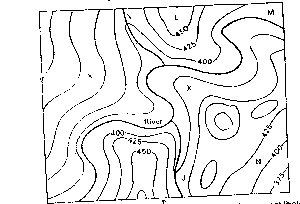
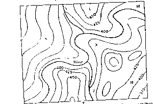
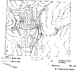
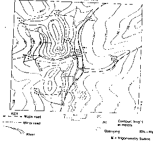
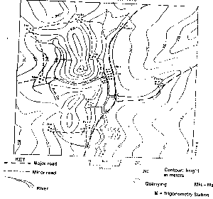
Question 0In the area covered by the contour map above, six men standing various places. Which of the men at J, K, L, M and N will NOT be able to see the man at X? (Assume that there is no vegetable cover; contours are in metres). The man is atA.JB.KC.LD.ME.NObjective Show full explanation
Question 0Which of the following statements is NOT true?A.In the tropical latitude, warm ocean currents wash the western sides of the continentsB.In the middle latitudes, warm ocean currents wash the western sides of the continentsC.In the higher latitudes, warm ocean currents wash the western sides of the continentsD.In the tropical latitudes, cool ocean currents wash the western sides of continentsE.In the higher latitudes, cool ocean currents wash the eastern sides of continenets.Objective Show full explanation
Question 0What is the approximate height of the location marked X?A.360 metresB.375 metresC.380 metresD.390 metresE.395 metresObjective Show full explanation
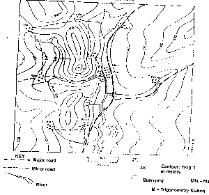
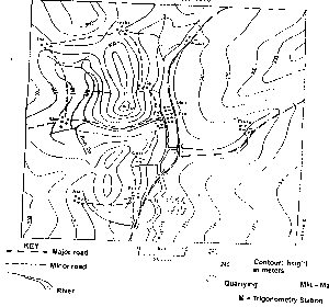
Question 0The length of the main road to the nearest kilometre isA.7 kilometreB.10 kilometreC.12 kilometreD.14 kilometreE.20 kilometreObjective Show full explanation
Question 0Name the feature crossed by the footpath between points Y and ZA.SpurB.Wind gapC.GorgeD.Dry valleyE.RidgeObjective Show full explanation
Question 0What is the size, in square kilometres of the area covered by the map?A.64.0 sq.kmB.62.0 sq.kmC.58.0 sq.kmD.55.0 sq.kmE.51.0 sq.kmObjective Show full explanation
Question 0What is the average gradient of the slope marked G-H?A.1:32B.1:34C.1:36D.1:38E.1:40Objective Show full explanation