Teacha
  • Courses
  • Mock Exams
  • For Tutors
  • For Schools
  • Pricing
Log InStart Free
  1. Past Questions
  2. /
  3. JAMB
  4. /
  5. Geography
  6. /
  7. 1988
  8. /
  9. Q0
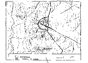
Question 0Question image

The gradient of the slope X-Y is approximately

  • A.1:24
  • B.1:26
  • C.1:28
  • D.1:30
  • E.
Objective

Question details

Exam body
JAMB
Subject
Geography
Year
1988
Question no.
#0
Type
Objective
Previous · Q0The hill slope along the line X-Y can be described as Next · Q0 The central landform in the area shown on the map can be described generally as…

More from this paper

  • Q0If the distance between two points on a map with scale 1: 50 000 is 28mm, what…
  • Q0If the bearing of a point J, from another point K, is 228°, what is the bearing…
  • Q0A line graph is best for showing geographical phenomena that?
  • Q0The most suitable method for depicting the production figures of a given…
  • Q0The best technique for illustrating population density is the?
  • Q0A soccer match which began at 1800 hours GMT at town Son longitude 90°W was…
See all Geography 1988 questions
Teacha

Africa's learning & exam readiness platform. Built for students, tutors, and schools.

Platform

  • Courses
  • Mock Exams
  • Past Questions

For You

  • I'm a Tutor
  • I'm a School
  • Pricing

© 2025 Teacha. Built for African learners, tutors, and schools. Teacha is not affiliated with WAEC, NECO, or JAMB. All past questions are sourced from publicly available materials.

Privacy PolicyTerms of UseCookie Policy