Question 0Which of the following statistical mapping techniques is most suitable for showing the spatial distribution of cattle in the different northern states of Nigeria?A.Dot mapB.IsoplethC.Pie graphD.Proportional circlesE.Objective Show full explanation
Question 0The flow diagram is the most appropriate mapping technique to use in showing?A.wind directions at different stationsB.movements of migrants between statesC.proportion of birds population in each stateD.man/land ratio in each stateE.Objective Show full explanation
Question 0In a divided circle illustrating the world's export of crude oil, the section taken up by the share of a certain country measures 72°. The share of that country's export expressed in a percentage is?A.10B.15C.20D.25E.Objective Show full explanation
Question 0At the summer solstice (June 21), which of the following latitudes will have the shortest night?A.60°NB.30°NC.30°SD.60°SE.Objective Show full explanation
Question 0The rotation of the earth on its axis?A.causes the varying lengths of day and nightB.is responsible for the change of the seasonsC.causes day and nightD.delimits the tropicsE.Objective Show full explanation
Question 0When it is noon at the Greenwich Meridian, the time is 5:30p.m on longitude?A.75° 3'WB.82° 30ÉC.82° 30'WD.75° 30'EE.Objective Show full explanation
Question 0Which of the following sedimentary rocks is mechanically formed?A.chalkB.coalC.shaleD.limestoneE.Objective Show full explanation
Question 0Under which of the following climates would you expect physical weathering to be normally most active?A.SavannahB.Hot DesertC.Warm TemperateD.EquatorialE.Objective Show full explanation
Question 0Which of the following landforms results from wind deposition?A.BarchanB.BajadaC.FanD.PlayaE.Objective Show full explanation
Question 0Which of the following requirements results virtually limits the area distribution of reef building corals to the tropical and sub-tropical zones?A.warm currentsB.shallow water of less than 30 metersC.mean water temperature not less than 20°CD.saline but sediments-free waterE.Objective Show full explanation
Question 0The Inter-tropical Discontinuity is the meeting zone of two air masses. These are the?A.Tropical Maritime and tropical ContinentalB.Tropical Maritime and the Polar ContinentalC.Tropical Continental and the Polar MartimeD.Tropical Maritime and Polar MaritimeE.Objective Show full explanation
Question 0On maps, places with equal sunshine duration are joined by?A.isohyetsB.isothermsC.isonephsD.isohelsE.Objective Show full explanation
Question 0In the temperate rain forest, most of the trees?A.are of softwoodB.are small in sizeC.are of hardwoodD.have needle-like leavesE.Objective Show full explanation
Question 0Which of the following trees evergreen and has small, thick, leathery and needle-shaped leaves?A.SpruceB.TeakC.OakD.EucalyptusE.Objective Show full explanation
Question 0Which of the following vegetation types is mainly confined to the Northern hemisphere?A.Tropical GrasslandB.Equatorial ForestC.TundraD.DesertE.Objective Show full explanation
Question 0A poorly-drained soil is characterized by greyish colour and?A.high acidityB.abundant ferric oxidesC.goosds aerationD.excessive drainageE.Objective Show full explanation
Question 0In which of the following climate belt is ferruginous soils found?A.Tropical aridB.Tropical continentalC.Temperate aridD.Temperate continentalE.Objective Show full explanation
Question 0Settlement listed in increasing size are?A.hamlet, conurbation, village , cityB.hamlet, village, city, conurbationC.village , conurbation, city, hamletD.village, hamelt, city, conurbationE.Objective Show full explanation
Question 0Which of these is the BEST indicator of high population density in rural area?A.High absolute populationB.Low natural resources baseC.High population densityD.Extensive soil erosionE.Objective Show full explanation
Question 0Eluviation is the process by which?A.soluble substances are removed from the upper layers of the soilB.soluble substances are deposited in the upper layers of the soilC.fine particles are removed from one layer of the soil to anotherD.Fine particles are deposited in the upper layers of the soilE.Objective Show full explanation
Question 0British Columbia, Iceland and Norway are noted for?A.lumberingB.miningC.fishingD.powerE.Objective Show full explanation
Question 0In which of the the following countries is land reclaimed from the sea intensively used for cultivation?A.BegiumB.EnglandC.FinlandD.HollandE.Objective Show full explanation
Question 0A major problem associated with lumbering in tropical as compared with temperate forests is that the?A.low density of rivers make log transportation costlyB.timber trees do not grow in pure standsC.hardwoods are not in great demandD.terrain is swampyE.Objective Show full explanation
Question 0The leading wheat producing region of the world is the?A.Pampas of ArgentinaB.Prairre of North AmericaC.Downs of AustraliaD.Veldt of South AfricaE.Objective Show full explanation
Question 0Transhumance is the seasonal migration of live-stock?A.from the lowlands to the uplandsB.from the north to the south following the rainsC.in the semiarid steppesD.in search of water and pastureE.Objective Show full explanation
Question 0Most of the industries located in rural areas are?A.market-orientedB.high energy consumersC.raw materials-orientedD.transport-orientedE.Objective Show full explanation
Question 0In recent years, many industrial firms in the advance countries have established branches in parts of South East Asia mainly because of the?A.ready market for their productsB.cheaper production costsC.cheaper and more steady supply of energyD.warmer and more equable climateE.Objective Show full explanation
Question 0Which of the following is NOT correct in terms of the country's major product for international trade?A.Manritius: sugarB.Libya: petroleumC.Zambia: copperD.Cote d'Ivoire: diamondE.Objective Show full explanation
Question 0What is the Sea of Japan noted for?A.MiningB.fishingC.RecreationD.Naval trainingE.Objective Show full explanation
Question 0Which of the following countries is famous for dairy farming?A.ArgentinaB.SwizerlandC.NetherlandsD.DemarkE.Objective Show full explanation
Question 0Which of the product listed below feature significantly in both the internal and external trade of Nigeria? i. Beans ii. Palm iii. Bananas iv. Cocoa V. Onions.A.i and VB.ii and ivC.iii and vD.ii and iiiE.Objective Show full explanation
Question 0Which of the following statements is TRUE of local craft industries in West Africa? i They are the earliest industries in the region. ii. They are widely scattered over the region. iii. Their products are mass produced. iv. They depend mainly on human energy.A.i, iii and ivB.ii, iii and ivC.i, ii and iiiD.i, ii and ivE.Objective Show full explanation
Question 0Which of the following is an important producer of iron ore?A.LiberiaB.The GambiaC.Burkina FasoD.GhanaE.Objective Show full explanation
Question 0Which of the following sets of major hydro-electric power projects are located in Africa?A.Boulder, Kariba, KainjiB.Owen Falls, Caborra Bassa, AswanC.Akosombo, Cunene, ItaipuD.Kainji, Sukhovo AswanE.Objective Show full explanation
Question 0Which of the following is a river port in Africa?A.MombasaB.KinshasaC.AlexandriaD.East LondonE.Objective Show full explanation
Question 0Where are the Ghezira Plains located and what crop is cultivated there?A.Sudan: cottonB.Mali: riceC.Egypt: cottonD.Uganda: sugarcaneE.Objective Show full explanation
Question 0The area shaded receives little rainfall becauseA.the coastal strip is narrowB.the area offshore is washed by a cool currentC.it lies on the windward side of the AndesD.the area off-shore is washed by a warm currentE.Objective Show full explanation
Question 0The natural vegetation of the shaded area isA.chaparralB.camposC.prairieD.cactiE.Objective Show full explanation
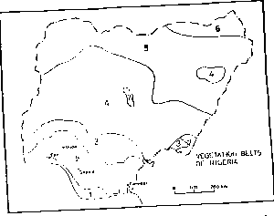
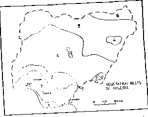
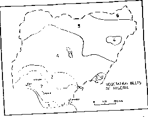
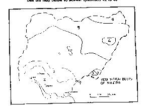
Question 0The vegetation belt numbered 4 on the map is theA.Derived savannahB.Guinea savannahC.Forest/savannah mosaicD.sudan savannahE.Objective Show full explanation
Question 0The equable climate and open grass vegetation free of tsetse flies, are responsible for the large scale movement of nomadic cattle during the dry season to the unit markedA.4B.5C.6D.7E.Objective Show full explanation
Question 0The largest concentration of domesticated livestock in Nigeria is found in the vegetation zone markedA.4B.5C.6D.7E.Objective Show full explanation
Question 0Mahogany, obeche , African walnut are timber trees characteristics of the vegetation zone markedA.1B.2C.3D.4E.Objective Show full explanation
Question 0Kanu State is a major producer of groundnutA.Rice and kolanutsB.Millet and SorghumC.Potatoes and TeaD.Millet and YamE.Objective Show full explanation
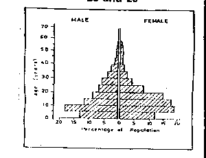
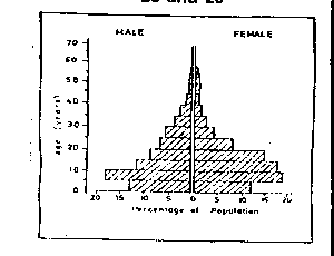
Question 0The population structure depicted above is that ofA.A young populationB.An ageing populationC.A stable populationD.A declining populationE.Objective Show full explanation
Question 0A major implication of this population structure is aA.A large productive labour forceB.High dependency ratioC.Relatively low investment in social servicesD.High life expectancyE.Objective Show full explanation
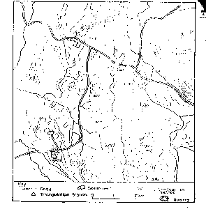
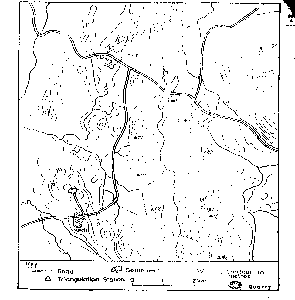
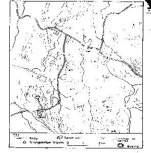
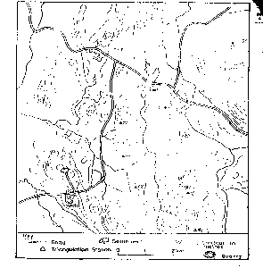
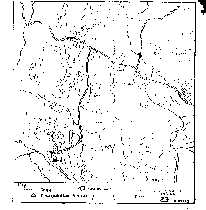
Question 0The highest point above mean sea level in the region is just aboveA.100mB.110mC.120mD.130mE.Objective Show full explanation
Question 0Which of these triangulation stations is NOT visible from the edge of the quarry?A.82B.94C.96D.105E.Objective Show full explanation
Question 0The settlements in the area mapped are located mainly on theA.Flood plainsB.Ridge topsC.FootslopesD.Valley floorsE.Objective Show full explanation
Question 0The settlements pattern is BEST described asA.NucleatedB.DispersedC.LinearD.NodalE.Objective Show full explanation
Question 0The landform between River Oni and the Kedi-Ibaga road is aA.Rolling plainB.Broken ridgeC.CuestaD.Fault-scarpE.Objective Show full explanation