Question 0Lines joining places of equal sunshine hours on a map are called?A.isobarsB.isothermsC.isohelsD.isohytesE.Objective Show full explanation
Question 0The most ideal statistical mapping technique for showing population migration is the?A.choroplethB.flow diagramC.isoplethD.dot mapE.Objective Show full explanation
Question 0A trader in town Y on Long. 30°W telephoned his uncle in town Z on Long. 60°E at 12.00 noon. The local time the uncle received the call was?A.6.00 a.mB.10.00 a.mC.2.00 p.mD.6.00 p.mE.Objective Show full explanation
Question 0The zone of uniform temperature in the atmosphere is known as the?A.troposphereB.stratosphereC.tropopauseD.ozone layerE.Objective Show full explanation
Question 0Basaltic plateaux are usually formed by a lava that is?A.basic and fluidB.acidic and fluidC.acidic and viscousD.basic and viscousE.Objective Show full explanation
Question 0Rocks, ash and sediments deposited by a volcano are collectively referred to as?A.lavaB.detritusC.pyroclastsD.screeE.Objective Show full explanation
Question 0The set of features produced in glaciated lowland includes all of?A.corries, pyramidal peak and eskersB.eskers, crag and tail and roche montaneeC.pyramidal peak, erratics and moraineD.corrie roche montanee and erraticsE.Objective Show full explanation
Question 0Four ways in which a river transports its load are?A.corrosion, saltation, solution and suspensionB.saltation, solution, suspension and tractionC.attrition, saltion, solution and suspensionD.corrosion, attrition, suspension and tractionE.Objective Show full explanation
Question 0The warm ocean current which washes the southeastern coast of Africa is called the?A.Benguela currentB.Guinea currentC.Canaries currentD.Agulhas currentE.Objective Show full explanation
Question 0Which of the following factors best explains the generally low isolation in the high latitudes?A.AltitudeB.ContinentallyC.Longitudinal positionD.Angel of inclinationE.Objective Show full explanation
Question 0In the northern winter, two well- defined low pressure cells are centered respectively on the North Atlantic Oceans because?A.the sea is relatively warmer than the landB.there are warm ocean currentsC.the northern parts of the oceans are shallowD.the seas are swept by strong windsE.Objective Show full explanation
Question 0Planetary winds are deflected on crossing the Equator due mainly to the effects of?A.Coriolis forceB.Ferrel's lawC.the jet streamD.gravitational forceE.Objective Show full explanation
Question 0Which savannah vegetation is characterized by grasses of about one metre high and scattered trees with flattish canopy?A.SahelB.SudanC.GuineaD.DerivedE.Objective Show full explanation
Question 0The process by which materials are physically transferred from one soil layer to another is called?A.leachingB.physical weatheringC.illuviationD.eluviationE.Objective Show full explanation
Question 0The most important environmental resources that sustains natural processes in an ecosystem is?A.lightB.waterC.airD.energyE.Objective Show full explanation
Question 0Nutrients lost by trees in leaf-fall can be re-used by the trees because the?A.trees are renewable resourcesB.nutrients circulate in the ecosystemC.nutrients are inexhaustibleD.trees store nutrientsE.Objective Show full explanation
Question 0Which of the following human disease is often heightened by the introduction of irrigation farming in an area?A.BilharziaB.DysenteryC.River blindnessD.CholeraE.Objective Show full explanation
Question 0One serious environmental hazard which may result from the destruction of the zone layer is?A.flooding due to melting of snowB.pollution of rain waterC.increase in atmospheric temperatureD.decrease in the quantity of oxygen in the atmosphereE.Objective Show full explanation
Question 0Dense population mainly dependent on peasant farming is found in?A.Witwatersrand in South AfricaB.the coastal areas of WestAfricaC.the Rwanda-Burundi areaD.the Katanga DistrictE.Objective Show full explanation
Question 0Rapid population growth is mainly the natural consequence of?A.low fertility and moralityB.rapid economic developmentC.high fertility with high moralityD.low morality with high fertilityE.Objective Show full explanation
Question 0The process by which population becomes largely concentrated at certain locations is called?A.migrationB.urbanizationC.nucleationD.agglomerationE.Objective Show full explanation
Question 0Which of the following is a nodal town?A.KumasiB.Port HarcourtC.BanjulD.MonroviaE.Objective Show full explanation
Question 0The least geographical factor that determined town sites in the past was the?A.existence of fertile alluvial plainsB.presence of indented coastlined sheltered from wavesC.existence of communication networksD.presence of a river gorgeE.Objective Show full explanation
Question 0Villages which lie along the foot of a chalk escarpment at head stream points are referred to as?A.fall-line settlementsB.fault-line villagesC.spring-line settlementsD.scarp-line villagesE.Objective Show full explanation
Question 0The area served by a given city is referred to as its?A.sphere of influenceB.hinterlandC.territoryD.sateliteE.Objective Show full explanation
Question 0Aluminum smelters are usually located close to sources of abundant?A.raw materialsB.electricityC.coking coalD.cheap labourE.Objective Show full explanation
Question 0A country is said to have been unfavorable balance of trade when her?A.tangible imports are greater in value than the tangible exportsB.tangible exports are greater in value than the tangible importsC.total payments for all visible and invisible imports exceed the corresponding total,exportsD.total receipts from all visible and invisible exports exceed the corresponding importsE.Objective Show full explanation
Question 0An unsuitable natural condition for the cultivation of cotton is?A.a loose sandy soilB.an annual rainfall of 500mm to 1000 mm with most of it falling in the growing seasonC.temperature of about 21° during growing seasonD.clear sunny skies after the plant is fully maturedE.Objective Show full explanation
Question 0An agricultural practice where water has to be artificially provided during the rainy season is referred to as?A.full irrigationB.supplementary irrigationC.sprinkle irrigationD.flood irrigationE.Objective Show full explanation
Question 0The leading rubber producing areas of the world are?A.Malaysia, Sri Lanka and GhanaB.Liberia, Indonesia and Sierra LeoneC.Brazil, Malaysia and ZarieD.Malaysia, Indonesia and Sri LankaE.Objective Show full explanation
Question 0Which of the following countries is one of the major producers of petroleum and also a net importer of the product?A.AlgeriaB.MexicoC.United States of AmericaD.NigeriaE.Objective Show full explanation
Question 0The cheapest means of transport for long distance travel is by?A.railB.waterC.airD.roadE.Objective Show full explanation
Question 0Which of the following is an entrepot?A.RotterdamB.New YorkC.SydneyD.LondonE.Objective Show full explanation
Question 0The global decline in the use of coal as a source of energy is due to the?A.increase in nuclear and water power generationB.increase in underground mining accidentsC.availability of cheaper and cleaner energy sourcesD.decline of the iron and steel industryE.Objective Show full explanation
Question 0One of the the main reasons for the formation Economic Community of West Africa States is to?A.foster political independence among member statesB.encourage tourism in the areaC.boost manufacturing in the regionD.expand the market for the products of member statesE.Objective Show full explanation
Question 0From which of the following lakes in Africa did the emission of toxic gas lead to the death of a large number of people in 1986?A.Lake MonoumB.Lake NyosC.Oguta LakeD.Lake NkongsambaE.Objective Show full explanation
Question 0The low level mechanized agriculture in West Africa is best explained by the?A.lack of marketsB.seasonal variation and unreliability of rainfallC.predominance of small farm holdingsD.undulating topographyE.Objective Show full explanation
Question 0Iron deposits are found in economic quantities in?A.Liberia, Sierra Leone and GuineaB.Mali, Nigeria and Cote d'IvoireC.Niger, Mali and Sierra LeoneD.Liberia, Nigeria and SenegalE.Objective Show full explanation
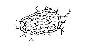
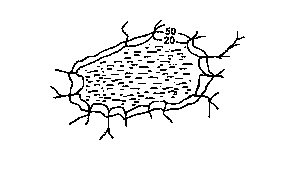
Question 0The drainage pattern illustrated in the diagram isA.annularB.centripetalC.radialD.trellisedE.Objective Show full explanation
Question 0The type of pattern illustrated is normally associated withA.BasinsB.domesC.troughsD.grabenE.Objective Show full explanation
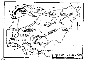
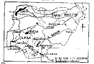
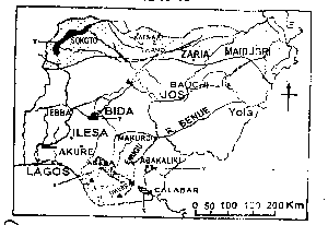
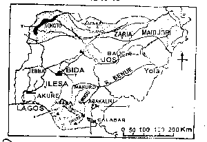
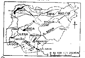
Question 0The point marked with solid triangles are the locations of Nigeria'sA.Thermal power stationsB.International airportsC.Automobile assemblyD.Oil refineriesE.Objective Show full explanation
Question 0The shaded areas labelled Y on the map are noted forA.Dry season wheat cultivationB.Floodland rice cultivationC.Large-scale fish farmingD.Large-scale irrigation farmingE.Objective Show full explanation
Question 0The shaded areas labelled X on the map indicate the probable areas of the occurrence ofA.PhosphateB.Natural gasC.MarbleD.LigniteE.Objective Show full explanation
Question 0The River marked R is the RiverA.GongolaB.YobeC.GuraraD.TarabaE.Objective Show full explanation
Question 0The shaded area labelled Z on the map indicates the part of Nigeria that suffers most fromA.River blindnessB.Tse-tse fly infestationC.Drought and desertification.D.Toxic waste pollutionE.Objective Show full explanation
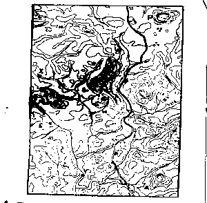
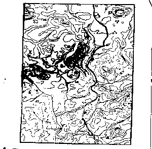
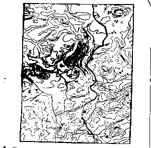
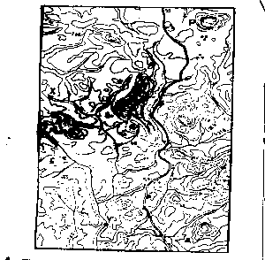
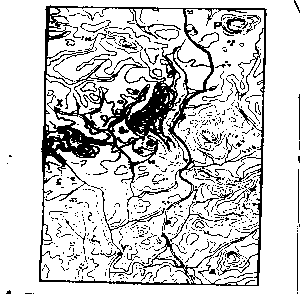
Question 0The length of the road is approximatelyA.8.0kmB.8.6kmC.9.2kmD.9.8kmE.Objective Show full explanation
Question 0The gradient along the main river between the points marked X and Y is approximatelyA.1:15B.1:16C.1:17D.1:18E.Objective Show full explanation
Question 0The feature marked P to the north-east isA.A monadnockB.A knollC.An inselbergD.A volcanoE.Objective Show full explanation
Question 0The bearing of Y from X is approximatelyA.155oB.160oC.165oD.170oE.Objective Show full explanation
Question 0The major constraint to road development in the area is theA.Vegetation coverB.DrainageC.Settlement patternD.TerrainE.Objective Show full explanation