Question 0The main advantage of the chain survey over the prismatic compass survey is that the formerA.yields relatively more accurate resultsB.involves highly more portable equipmentC.does not require a base mapD.closes its boundaries with no correctionE.Objective Show full explanation
Question 0The main use of the Abney Level in surveying is to determine theA.angle of inclinationB.relative locationC.area coverageD.spot heightE.Objective Show full explanation
Question 0A typical example of landforms produced by marine erosion is aA.beachB.spitC.mud-flatD.stackE.Objective Show full explanation
Question 0When the gradient of a river channel changes from a steep to a gentle angle, the main activity of the river will beA.depositingB.erodingC.deepeningD.terracingE.Objective Show full explanation
Question 0The period when the earth is furthest from the sun isA.aphelionB.summerC.perihelionD.springE.Objective Show full explanation
Question 0A traveller crossing the international Date Line from America to Asia at 12 midnight on Sunday, would have to change his watch to 12 midnight onA.SundayB.MondayC.TuesdayD.SaturdayE.Objective Show full explanation
Question 0Lakes formed as a result of landslides, screes or avalanches are known asA.man-made lakesB.barrier lakesC.caldera lakesD.rock-hollow lakesE.Objective Show full explanation
Question 0In many areas, limestone rocks are resistant to water erosion on their surfaces and form uplands because of theirA.coarse and resistant mineralsB.low porosity and permeabilityC.dense and armophous structureD.joints and pervious natureE.Objective Show full explanation
Question 0Fluid, basic lava flow is likely to give rise to a volcanicA.domeB.cinder coneC.shieldD.saddle reefE.Objective Show full explanation
Question 0Urban floods are mainly caused byA.construction of dams and barragesB.clearance of vegetation on farmlandsC.blockage of drains and waterwaysD.establishment of shelter beltsE.Objective Show full explanation
Question 0The vegetation of the warm Temperate Eastern Margin is characterized byA.evergreen shrubs and thicketsB.mixed deciduous and coniferous forestsC.mixed tropical rainforests and monsoonal forestsD.mixed coniferous and broad-leaved evergreen forestsE.Objective Show full explanation
Question 0The heavy dark soil associated with floodable valley-bottoms is aA.lateritic soilB.ferrallitic soilC.podzolic soilD.hydromorphic soilE.Objective Show full explanation
Question 0Which of the following is a major environmental problem in heavily industrialized regions?A.Accelerated erosionB.Water pollutionC.Frost damageD.Acid rainE.Objective Show full explanation
Question 0A fog is most likely to develop when aA.warm moist wind blows over a warm currentB.warm moist wind blows over a cold currentC.cold, dry winds blows over a warm currentD.warm, dry winds blows over a cold currentE.Objective Show full explanation
Question 0One factor which helps to account for the dryness of the Sahara desert is theA.height of the jet stream over the areaB.persistence of a high pressure belt over the areaC.complete absence of vegetation over much of the areaD.impact of oil production by the countries of that regionE.Objective Show full explanation
Question 0The circulation of the oceans and the atmosphere primarily help to redistribute and equalize globalA.heatB.floraC.oxygenD.faunaE.Objective Show full explanation
Question 0Soils with well developed profiles formed mainly under the influence of the regional climate and vegetation are said to beA.azonalB.zonalC.intrazonalD.colluvialE.Objective Show full explanation
Question 0Environmentalists agree that there is a general rise in sea level as a result ofA.excessive rainfallB.excavation of sand from ocean bedsC.global warmingD.man-induced erosion along sea coastsE.Objective Show full explanation
Question 0The set of trees most suitable for pulp and paper making isA.spruce, mahogany and obecheB.fir, obeche and ebonyC.spruce, fir and pineD.pine, eucalyptus and mahoganyE.Objective Show full explanation
Question 0The population of a certain country was observed to be 46 million males and 41 million females within a land area of about 173,000km2. What is the average density of the population?A.503 persons per km2B.351 persons per km2C.266 persons per km2D.237 persons per km2E.Objective Show full explanation
Question 0Modern satellite towns are commonly characterized byA.central city location, roomy houses and high building densityB.suburban location, planned layout and spacious surroundingsC.industrial estate location, low building density and limited open spacesD.rural location, planned layout and high rise apartmentsE.Objective Show full explanation
Question 0An extensive fertile plain with a relatively low population will most likely be characterized byA.great conurbationsB.linear, rural settlementsC.nucleated urban settlementsD.scattered rural settlementsE.Objective Show full explanation
Question 0International agreements in the fishing industry are necessary in order to protect whale and seal fromA.maraudingB.stock extinctionC.sea piracyD.sea accidentE.Objective Show full explanation
Question 0Many industries in Europe and America have established branches in South East Asia in order to reduceA.production costsB.transport costsC.raw material shortagesD.comparative advantageE.Objective Show full explanation
Question 0Expressways mainly help intracity traffic in thatA.the multiple lanes can hold more trafficB.vehicles can move at high speedC.they divert traffic awasy from the cityD.new motor parks can be sited along themE.Objective Show full explanation
Question 0The best climate for the production of tea isA.monsoonB.maritimeC.equatorialD.temperateE.Objective Show full explanation
Question 0The harmattan wind in Nigeria is associated withA.Tropical Continental AirmassB.Equatorial Maritime AirmassC.Tropical Maritime AirmassD.Polar Continental AirmassE.Objective Show full explanation
Question 0Three ethnic groups of the Niger Delta region of Nigeria areA.Ibibio, Tiv and IjoB.Igbo, Idoma and IjoC.Ijo, Urhobo and ItshekiriD.Itshekiri, Igbo and IbibioE.Objective Show full explanation
Question 0The sequence of savannah vegetation zones in Nigeria towards the northern part isA.Derived, Sahel, Guinea and SudanB.Derived, Guinea, Sudan and SahelC.Derived, Sudan, Guinea and SahelD.Derived, Guinea, Sahel and SudanE.Objective Show full explanation
Question 0Oil refineries are found in which of the following sets of states?A.Cross River, Rivers and EdoB.Edo, Delta and KadunaC.Cross River, Edo and KadunaD.Rivers, Delta and KadunaE.Objective Show full explanation
Question 0In Nigeria, hydroelectric and thermal energies are generated respectively inA.Ijora and Oji riverB.Afam and IjoraC.Kainji and Oji riverD.Kura falls and KainjiE.Objective Show full explanation
Question 0On the Jos plateau, tin and columbite are obtained mainly fromA.older granitesB.volcanic conesC.wind depositsD.alluvial depositsE.Objective Show full explanation
Question 0Which of the following groups of people is not found in West Africa?A.WolofB.MandingoC.MossiD.ShonaE.Objective Show full explanation
Question 0The most important gold mining town in Africa isA.IlesaB.ObuasiC.JohannesburgD.BouakeE.Objective Show full explanation
Question 0An African port that handles more of other countries products than its own isA.Sofala (Beira)B.Cape TownC.LuandaD.MombasaE.Objective Show full explanation
Question 0Power for aluminium smelting is one of the principal objectives of the hydro-electric project inA.KaribaB.ShiroroC.AkosomboD.KainjiE.Objective Show full explanation
Question 0An example of a horst in Africa isA.KilimanjaroB.RuwenzoriC.CameroonD.Erta AleE.Objective Show full explanation
Question 0The group of countries that produce most of the cocoa in West Africa isA.Ghana, Sierra Leone and GambiaB.Ghana, Cote d'Ivoire and Republic of BeninC.Ghana, Nigeria and Cote d'IvoireD.Nigeria, Cote d'Ivoire and TogoE.Objective Show full explanation
Question 0The two dams found in the Upper and Lower Nile respectively areA.Sennar and Jebbel AuliaB.Gezira and SennarC.Aswan and Jebel AuliaD.Sennar and AswanE.Objective Show full explanation
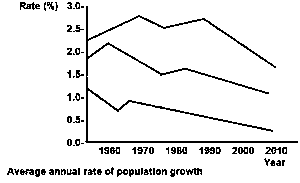
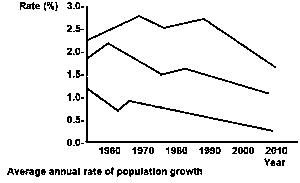
Question 0Which of these statements is true concerning the three rates illustrated above?A.The rate were highest in 1950 and declined steadily throughthe yearsB.The world rate is closer to that of the more developed region than that of the less developedC.The average world rate of growth in 2010 is less than the other two ratesD.the rate of the more developed regions virtually declined through-out the periodE.Objective Show full explanation
Question 0The range of population growth in the less developed regions during the period illustrated is approximatelyA.2.1 to 2.7%B.1.6 to 2.7%C.1.4 to 2.1%D.0.4 to 1.6%E.Objective Show full explanation
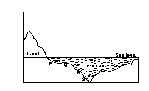
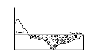
Question 0the ocean feature at point S is best described asA.a submarine ridgeB.an ocean floorC.an ocean dipD.a continental edgeE.Objective Show full explanation
Question 0The section labelled R representsA.An offshore beachB.a continental shelfC.a continental slopeD.a marine platformE.Objective Show full explanation
Question 0A profile drawn along LK, north east of River Aye describesA.Convex slopeB.Concave slopeC.Straight slopeD.Convex-concave slopeE.Objective Show full explanation
Question 0Aperi is an example of aA.Confluence settlementB.Foothill settlementC.Wet-point settlementD.Dry-point settlementE.Objective Show full explanation
Question 0The drainage pattern of the area shown isA.TrellisB.DendriticC.RadialD.CentripetalE.Objective Show full explanation
Question 0The prominent feature running approximately N.W to S.E is best described asA.A ridgeB.A spurC.An escarpmentD.An embankmentE.Objective Show full explanation
Question 0The distance between the two confluences along River Kedi isA.9.7kmB.10.7kmC.11.7kmD.12.7kmE.Objective Show full explanation