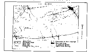
Question 0A direct natural consequence of drought isA.famine and starvationB.high mortality rate in livestockC.drying up of most water sourcesD.change in the chemical property of soilsE.Objective Show full explanation
Question 0The most common tree in the desert is theA.dateB.acaciaC.pineD.larchE.Objective Show full explanation
Question 0The most obvious physical feature that distinguishes undisturbed mature soil from an immature soil is theA.humus contentB.layered profileC.nutrient statusD.topsoil textureE.Objective Show full explanation
Question 0The direction of flow of ocean currents is determined mainly by theA.rotation of the earth and land and sea breezesB.shape of the continents and the temperature of the continental interiorC.prevailing winds and the rotation of the earthD.depth of the ocean and the amount of fresh water inflowE.Objective Show full explanation
Question 0The medium class of layered cloud which brings continuous rain, snow or sleet is theA.altocumulusB.altostratusC.stratocumulusD.nimbostratusE.Objective Show full explanation
Question 0The biodiversity of an ecosystem may be reduced through theA.extinction of plant speciesB.removal of a single animalC.introduction of a new plantD.trapping of a single fishE.Objective Show full explanation
Question 0A soft, black opaque carbonaceous rock that can be used to make pencils isA.ligniteB.graphiteC.leadD.coalE.Objective Show full explanation
Question 0The vegetation that is characterized by tall trees climbing plants and creepers in the Amazon is calledA.pampasB.veldtC.selvasD.steppesE.Objective Show full explanation
Question 0One predominantly temperate grain that is being cultivated in some tropical areas today isA.sorghumB.barleyC.maizeD.wheatE.Objective Show full explanation
Question 0The scientist who prepounded the theory of continental drift wasA.Alfred WegenerB.William DavisC.Arthur HolmesD.Francis BaconE.Objective Show full explanation
Question 0A sedimentary rock formed only in seas and oceans in warm tropical and subtropical environments isA.shaleB.limestoneC.sandstoneD.mudstoneE.Objective Show full explanation
Question 0Exfoliation and rock disintegration are weathering processes only found in theA.tundra regionB.savannah regionC.desert regionD.mediterranean regionE.Objective Show full explanation
Question 0An area of the world that is likely to have 24-hour sunshine on July 15 of any year is theA.Horse latitudesB.Southern polar areaC.Equatorial areaD.Northern polar areaE.Objective Show full explanation
Question 0Where winds are onshore, warm ocean currents will bring a type of condition to the coastland that isA.cool and dryB.warm and wetC.cold and wetD.hot and dryE.Objective Show full explanation
Question 0The speed of the wind is usually measured byA.an anemometerB.a speedometerC.an arrowD.a wind vaneE.Objective Show full explanation
Question 0Acid lava is rich inA.magnesiumB.aluminiumC.silicaD.silverE.Objective Show full explanation
Question 0The live commentary of a football match which started at 4:00pm at a place on longitude 15°E will be received by a listener in a town on longitude 160°W atA.6:20am same dayB.4:20am same dayC.1:40am next dayD.3:40am next dayE.Objective Show full explanation
Question 0During winter, the Eskimos live inA.tentsB.tunnelsC.cavesD.igloosE.Objective Show full explanation
Question 0Johannesburg, Jos and Galhivare are similar in that they allA.act as nodal townsB.have population of over a millionC.grew because of the presence of mineralsD.act as commercial centresE.Objective Show full explanation
Question 0The shaduf method of irrigation was first practiced inA.EgyptB.GhanaC.SudanD.NigerE.Objective Show full explanation
Question 0Dairy farming is most notable inA.EgyptB.DenmarkC.JapanD.ChinaE.Objective Show full explanation
Question 0The least of the factors to be considered in the location of industries isA.raw materialsB.transportC.marketsD.climateE.Objective Show full explanation
Question 0The rise in the population of an area can be measured easily byA.multiplying the natural increase by the net migrationB.subtracting the natural increase from the net migrationC.adding the natural increase to the migrationD.dividing the natural increase by the net migrationE.Objective Show full explanation
Question 0Transportation is an important economic activity because itA.promotes diffusion of innovation and ideasB.facilitates urban-rural migrationC.promotes the health of national populationD.helps to achieve economic independenceE.Objective Show full explanation
Question 0Which of these sets enhances nucleation of rural settlements?A.Several sources fo water and wet pointsB.Narrow valleys and rugged highlandsC.Fertile broad plains and natural harboursD.Dissected plains and wet intersectionsE.Objective Show full explanation
Question 0The movement of a group of people from a village to an irrigation project area may be described asA.urban-urban migrationB.rural-urban migrationC.urban-rural migrationD.rural-rural migrationE.Objective Show full explanation
Question 0The most important factors influencing the distribution of population in the world areA.climate, relief, soils and mineral resourcesB.climate, industrial activities, soils and tourismC.climate, soils, agriculture and cultural activitiesD.relief, industrial activities, agriculture and mineral resourcesE.Objective Show full explanation
Question 0The most dreaded pest in the Cotton Belt of the U.S.A is theA.weaver birdB.beetleC.bollweevilD.white antE.Objective Show full explanation
Question 0The Benguela current is to Namibia what the canaries current is toA.KenyaB.AngolaC.MozambiqueD.MauritaniaE.Objective Show full explanation
Question 0The two prominent highlands at the Nigeria-Cameroun border areA.Mambila and ObanB.Mandara and AlantikaC.Udi and ShebshiD.Jos Plateau and KukurukuE.Objective Show full explanation
Question 0An important mineral deposit in South Africa which has attracted a large number of white settlers isA.iron in DurbanB.copper in Cape TownC.gold in WitwatersrandD.aluminium in JohannesburgE.Objective Show full explanation
Question 0The prosperity of Kenya depends upon the cultivation ofA.coffee, sisal and riceB.coffee, cocoa and riceC.coffee, rubber and maizeD.coffee, maize and sisalE.Objective Show full explanation
Question 0One major feature of manufacturing in West Africa is that the industriesA.are evenly spread over major townsB.produce mainly for domestic marketC.are capital intensiveD.have wide markets for their productsE.Objective Show full explanation
Question 0The most important air masses which affect the climate of Nigeria are theA.tropical maritime and tropical sea and land breezesB.tropical maritime and the equatorial westerliesC.tropical maritime and the tropical continentalD.tropical maritime and the polar continentalE.Objective Show full explanation
Question 0The low rainfall along Cape Three Points in Ghana is due to theA.upwelling of cold waterB.sparse vegetationC.prevalence of south west windsD.upwelling of warm waterE.Objective Show full explanation
Question 0In Nigeria, the dominant trees of the Guinea Savannah includeA.isoberlinia, obeche and locust beanB.isoberlinia, shea butter and silk cottonC.acacia, dum palm and silk cottonD.locust bean, oil bean and acaciaE.Objective Show full explanation
Question 0From its source to its mouth, the River Niger passes throughA.Mali, Guinea, Niger and NigeriaB.Guinea, Mali, Togo and NigeriaC.Guinea, Mali, Niger and NigeriaD.Mali, Niger, Guinea and NigeriaE.Objective Show full explanation
Question 0An environmental hazard which occurs slowly and unnoticed in the oil-producing region of the Niger Delta of Nigeria isA.erosionB.pollutionC.floodD.subsidenceE.Objective Show full explanation
Question 0One basic mineral that is common to Sokoto, Ewekoro, Calabar and Nkalagu isA.coalB.marbleC.limestoneD.gypsumE.Objective Show full explanation
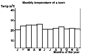
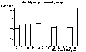
Question 0The modal temperature for the town isA.23oCB.25oCC.29oCD.30oCE.Objective Show full explanation
Question 0The annual range of temperature for the town isA.7oCB.17oCC.23oCD.30oCE.Objective Show full explanation
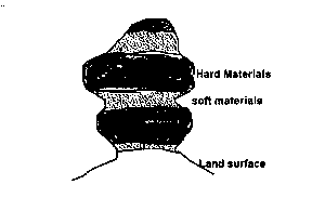
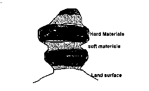
Question 0The feature is a product ofA.glacial erosionB.wind abrasionC.water erosionD.wind depositionE.Objective Show full explanation
Question 0The landform is aA.yardangB.zeugenC.mesa and butteD.rock pedestalE.Objective Show full explanation
Question 0The technique that would produce the most accurate contoured map of a small area isA.Prismatic compass surveyB.Land-use surveyC.Plane-table surveyD.Chain surveyE.Objective Show full explanation
Question 0In Nigeria, continentality poses the greatest hindrance to economic development in theA.Niger DeltaB.Niger Benue TroughC.Cross River BasinD.Chad BasinE.Objective Show full explanation
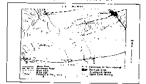
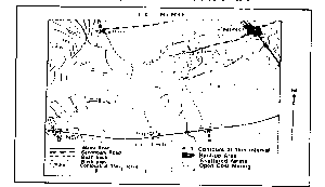
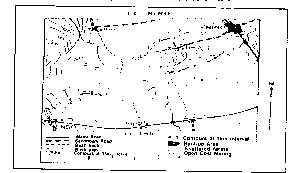
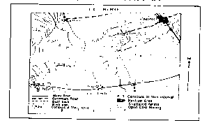
Question 0The feature marked X is best described as aA.PassB.ColC.GapD.PathE.Objective Show full explanation
Question 0Roads and settlements are restricted in the area because of theA.Steep hill slopesB.Mining activitiesC.Presence of many riversD.Predominance of footpathsE.Objective Show full explanation
Question 0The bearing of the end of the secondary road at Ned from the road junction at Gag is approximatelyA.80oB.170oC.260oD.350oE.Objective Show full explanation
Question 0The approximate elevation of the spot height indicated on the eastern peak isA.725kmB.715kmC.710kmD.695kmE.Objective Show full explanation