Question 0In surveying, fixed obstacles are best dealt with by?A.avoiding themB.using abney levelC.removing themD.laying offsetsE.Objective Show full explanation
Question 0The most suitable statistical diagram to show spatial distribution of population is the?A.divided circleB.dot mapC.pie chartD.line graphE.Objective Show full explanation
Question 0The main purpose of any ground survey is toA.make an accurate map of a part of the earth's surfaceB.measure and record lines and angles of a placesC.derive accurate baseline data for urban planningD.have a detailed knowledge of the geology of a placeE.Objective Show full explanation
Question 0The main advantage of plane tabling as a survey method is that it?A.is a fast methodB.gives accurate results in most situationsC.is an all weather methodD.requires little or no skill to useE.Objective Show full explanation
Question 0Bees and butterflies are important to flowering plants because they?A.pollinate the plantsB.satisfy human needsC.produce honeyD.extract excess nectarE.Objective Show full explanation
Question 0A depositional landform occurring where streams emerge a mountain area in a desert is?A.a seif duneB.a playa lakeC.a rock pedestalD.an alluvial fanE.Objective Show full explanation
Question 0The prairies of North America are?A.montane grasslandsB.temperate desertsC.tropical grasslandsD.temperate grasslandsE.Objective Show full explanation
Question 0The variable which is both a control and an element of weather and climate is?A.windB.airmassC.temperatureD.rainfallE.Objective Show full explanation
Question 0The Stevenson's screen is raised about one metre above the ground in order to avoid?A.rain drops entering itB.the influence of strong windsC.the effects of nearby treesD.the heat from the groundE.Objective Show full explanation
Question 0The greatest threat to the world's wildlife population is?A.the poor management of game reserversB.the development of zological gardensC.excessive huntingD.the destruction of habitatsE.Objective Show full explanation
Question 0The formation of coal is associated with?A.landslides and depositionB.earth movement and pressureC.heat and pressureD.earth tremor and heatE.Objective Show full explanation
Question 0A hazard that could be traced directly to ozone layer depletion is the?A.escalation of the melting of polar and temperate ice capsB.introduction of ultra violet rays into the troposhereC.submergence of numerous coastal settlements in the worldD.extension of desert-like conditions to the savannahE.no optionObjective Show full explanation
Question 0An example of a landform produced by glaciation is?A.a cirqueB.a sand-duneC.an ox-bow lakeD.an inselbergE.Objective Show full explanation
Question 0The vertical section of the soil from the surface down to the bedrock, showing different layers, is known as soil?A.colourB.profileC.textureD.horizonE.Objective Show full explanation
Question 0The time difference between a place on longitude 35°W and another on longitude 25°E is?A.2 hoursB.3 hoursC.5 hoursD.4 hoursE.Objective Show full explanation
Question 0High temperatures and heavy rainfall throughout the year describe the climate of?A.India, Uganda and EthiopiaB.Sierra Leone, Nigeria and GhanaC.Democratic Republic of Congo, Brazil and IndonesiaD.Britain, North and South Korea and NambiaE.Objective Show full explanation
Question 0The Dead Sea is the most saline lake in the world because?A.it is surrounded by saline rocksB.sea water seeps into itC.no river flows out of itD.it is located in the desertE.Objective Show full explanation
Question 0An igneous rock with distinct grains of mica, feldspar and quartz is?A.schistB.basaltC.rhyoliteD.graniteE.Objective Show full explanation
Question 0High tides are produced when the?A.moon is perpendicular to the earth's axisB.earth completes a revolution round the sunC.earth, the moon and the sun are on a straight lineD.sea level rises because of the earth's rotationE.Objective Show full explanation
Question 0The world's leading producer of cocoa is?A.EcuadorB.GhanaC.BrazilD.NigeriaE.Objective Show full explanation
Question 0The basic raw materials for the textile industry include?A.cotton, wool, jute and rubberB.flax, wool, pulp and papyrusC.cotton, wool, pulp and papyrusD.flax, wool, silk and cottonE.Objective Show full explanation
Question 0The main problem faced by export crop producers in developing countries is?A.pests and diseasesB.widely fluctuating pricesC.high cost of inputsD.lack of capitalE.Objective Show full explanation
Question 0The population of a town in 1975 was 210,000 but grew to 280,000 in 1980. What was the the annual growth rate?A.15.0%B.6.7%C.33.3%D.26.7%E.Objective Show full explanation
Question 0Western Europe and North Eastern U.S.A. are the most industrialization regions of the world because they?A.have abundant human and natural resourcesB.are density populatedC.are on either side of the Altantic OceanD.have high per capita incomeE.Objective Show full explanation
Question 0Which of the following pairs of cities have both a seaport and an international airport?A.Rio de Janeiro and JohannesburgB.Lagos and San FranciscoC.New York and WarriD.Kampala and MombasaE.Objective Show full explanation
Question 0The sex ratio of any population may be affected by?A.mortalityB.morbidityC.migrationD.fertilityE.Objective Show full explanation
Question 0Crude oil constitutes the bulk of the export products of?A.Nigeria,Cote d'lvoire, Kuwait and AustraliaB.Australia, Java, Nigeria and LibyaC.Libya, Qatar, Ghana and Saudi ArabiaD.Qatar, Nigeria, Kuwait and Saudi ArabiaE.Objective Show full explanation
Question 0The merging together of a number of urban settlements will produce a?A.conurbationB.nucleated settlementC.linear settlementD.suburbE.Objective Show full explanation
Question 0Automobile industries that are essentially assembly plants are found in?A.West AfricaB.South AfricaC.West EuropeD.North East U.S.A.E.Objective Show full explanation
Question 0Nucleated groups of houses occupied largely by people engaged in primary occupation are referred to as?A.metropolisesB.villagesC.farmsteadsD.townsE.Objective Show full explanation
Question 0The groups of hardwoods that are suitable for railway sleepers in Nigeria is?A.gmelina, teak and spruceB.obeche, mahogany and pineC.pine, fir and mahoganyD.mahogany, obeche and irokoE.Objective Show full explanation
Question 0The relative dryness of the Horn of Africa is due to?A.the dominance of cold currents in the regionB.the distance from the belt of tropical cyclonesC.its closeness to the high ranges of East AfricaD.the shape and direction of the shorelineE.Objective Show full explanation
Question 0The most capital-intensive sector of the Nigerian economy today is?A.transportationB.agricultureC.miningD.tradingE.Objective Show full explanation
Question 0A country well known for the production of copper in Africa is?A.GhanaB.Republic of BeninC.ZambiaD.EgyptE.Objective Show full explanation
Question 0The major problems associated with rapid urban growth in tropical Africa are?A.over-population, traffic congestion and urban-rural migrationB.tyraffic congestion, neglect of agriculture and urban-rural migrationC.rural-urban migration, unemployment and rising crime rateD.rural-urban migration, unemployment and rising crime rateE.Objective Show full explanation
Question 0The development of a climax vegetation in the savannah belt of Nigeria is disturbed mainly by?A.lumberingB.miningC.bush burningD.animal grazingE.Objective Show full explanation
Question 0The areas in Nigeria where temperate crops may be grown include?A.Jos, Plateau and Mambilla plateauB.Mandara Mountains and Biu PlateauC.Apata Hills and Effong RidgeD.Oban Hills and Yoruba HighlandsE.Objective Show full explanation
Question 0Examples of fold mountains in Africa are?A.Drakensberg Mountains and Mount CamerounB.Altas Mountains and Mount KenyaC.Cape Ranges and Atlas MountainsD.Mount Kilimanjaro and Atlas MountainsE.Objective Show full explanation
Question 0The most densely populated city which is also the capital of a country in Africa is?A.DakarB.Cape TownC.AbujaD.CairoE.Objective Show full explanation
Question 0A good example of cuesta landscape in Nigeria is?A.Biu PlateauB.Udi HillsC.Yoruba HillsD.North Central HighlandsE.Objective Show full explanation
Question 0The greatest environmental problem around Nkalagu and Ewekoro is?A.man-madelakesB.air pollutionC.land subsidenceD.water pollutionE.Objective Show full explanation
Question 0Nigerian recently entered into trade agreements in petroleum products and gas with?A.all West Africa countriesB.most countries of North AfricaC.some West African countriesD.all African countriesE.Objective Show full explanation
Question 0Lakes Kivu and Malawi are related in that they?A.attract a large number of touristB.lie in the Northern HemisphereC.are rift valley lakesD.are crater lakesE.Objective Show full explanation
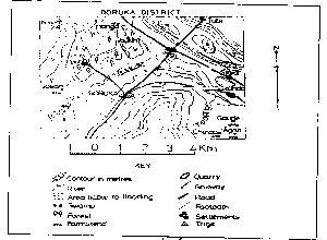
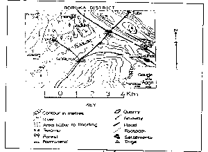
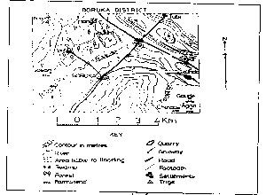
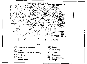
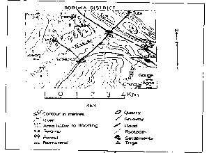
Question 0The crop that will be most suitable for cultivation in the lower basin of River Madu isA.CoffeeB.GroundnutC.CottonD.RiceE.Objective Show full explanation
Question 0The feature running approximately north to north-east on which the trigonometrical station is located is aA.Conical hillB.CliffC.RidgeD.PlateauE.Objective Show full explanation
Question 0The distance as the crow flies between the trigonometrical station and Josan is approximatelyA.5.5kmB.5.0kmC.6.5kmD.6.0kmE.Objective Show full explanation
Question 0The most prominent economic activity in the North-Western part of the area is likely to beA.MiningB.LumberingC.Mixed farmingD.Animal husbandryE.Objective Show full explanation