Question 0Which is the simplest method of rapid distance measurement in surveying?A.PacingB.Tape measurementC.ChangingD.Compass measurementE.Objective Show full explanation
Question 0Tin-mining activities in Nigeria are the main causes of environmental degradation on the?A.Western HighlandsB.Eastern HighlandsC.Jos PlateauD.Obudu PlateauE.Objective Show full explanation
Question 0In the Niger Delta, the features that are clearly visible are?A.white sandy beaches, tall trees and salt-water swampsB.white sandy beaches, reddish sandy beaches and mangrove treesC.white sandy beaches, tall trees and reddish sandy beachesD.white sandy beaches, salt-water swaps and mangrove treesE.Objective Show full explanation
Question 0Most of the iron ores produced in Africa are exported because?A.the producing countries have good transport systems to coastal portsB.the producing countries have low internal consumption capacitiesC.they can only be smelted in modern furnaces that are not locally availableD.they are of good quality and in high demandE.Objective Show full explanation
Question 0The oldest system of agriculture in Nigeria which now survives only in very remote areas is?A.mixed farmingB.shifting cultivationC.marketing gardeningD.bush fallowingE.Objective Show full explanation
Question 0The ECOWAS is comparable to the European Union in terms of?A.a unified security arrangementB.a common border agreement and policingC.the freedom of movement within the communityD.uniform currencies besides the local onesE.Objective Show full explanation
Question 0Two examples of inland drainage lakes in Africa are?A.Lake Chad and Lake EdwardsB.Lake Victoria and Lake NgamiC.Lake Chad and Lake TurkanaD.Lake Malawi and Lake TurkanaE.Objective Show full explanation
Question 0The highest lands in Nigeria are found on the?A.Mambilla PlateauB.Oban HillsC.North Central PlateauD.Western HighlandsE.Objective Show full explanation
Question 0Unemployment and underemployment are at high levels in West Africa cities because?A.the people in these cities are lazyB.there is a large youthful populationC.many of the city-dwellers are skilledD.industrialization is at a slow paceE.Objective Show full explanation
Question 0The port that handles the highest volume of timber export in Nigeria is?A.SapeleB.WarriC.Port HarcourtD.LagosE.Objective Show full explanation
Question 0Oil production has made much impact on the development of?A.GabonB.libyaC.AlgeriaD.GhanaE.Objective Show full explanation
Question 0Textile industries in Nigeria are located mostly at?A.AbaB.OyoC.KadunaD.KanoE.Objective Show full explanation
Question 0The major factor responsible for the low population density in the west coast of Southern Africa is?A.slave tradeB.low rainfallC.rugged reliefD.disease infestationE.Objective Show full explanation
Question 0Examples of African rivers with deltaic mouths include the?A.Niger, Nile, Orange and ZambeziB.Nile, Zaire, Niger and LimpopoC.Nile, Niger, Senegal and VoltaD.Zambezi, Nile, Volta and NigerE.Objective Show full explanation
Question 0The proportion of the earth's surface occupied by oceans is approximately?A.87%B.67%C.97%D.77%E.Objective Show full explanation
Question 0In the humid tropical lands, structure of mature forests is closely related to the demand for?A.lightB.shadeC.waterD.foodE.Objective Show full explanation
Question 0Rocks which contain metals in concentrations high enough to be economically profitable to extract and refine are referred to as?A.terrestrial resourcesB.oresC.ferrous depositD.mineralsE.Objective Show full explanation
Question 0Which of the following groups consists of energy resources?A.Petroleum, uranium and manganeseB.coal, bauxite and uraniumC.water, copper and sunD.Coal, Petroleum and waterE.Objective Show full explanation
Question 0Spruce, fir and pine are tress found in the?A.Mediterranean woodlandsB.Monsoon forestC.Coniferous forestsD.Tropical rainforestsE.Objective Show full explanation
Question 0Which of these hazards would most likely result directly from deforestation?A.Water pollutionB.Soil erosionC.Mass wastingD.DroughtE.Objective Show full explanation
Question 0The mass of air whose isobars form a circular shape, with low pressure in the centre and increasing towards the outside, is known as?A.hurricaneB.typhoonC.harmathanD.cycloneE.Objective Show full explanation
Question 0The process by which organic matter is decomposed and synthesized to form part of the soil is known as?A.humificationB.mineralizationC.laterizationD.nitrificationE.Objective Show full explanation
Question 0In a ecosystem, bacteria and some other microscopic organisms are best described as?A.secondary consumersB.major decomposersC.primary decomposersD.primary consumersE.Objective Show full explanation
Question 0The process whereby water changes from liquid to gaseous state is called?A.freezingB.condensationC.evaporationD.sublimationE.Objective Show full explanation
Question 0A serious environmental hazard which causes both vertical lateral displacement of part of the earth's crust is?A.earthquakeB.volcanoC.landslideD.weatheringE.Objective Show full explanation
Question 0If the standard time is of a country is GMT + 1hr, which longitude's local time is adopted by the country?A.60°WB.60°EC.16°WD.15°EE.Objective Show full explanation
Question 0Migrant-receiving areas tend to be characterized by?A.equal sex ratioB.high per capita incomeC.the predominance of malesD.extensive industrial developmentE.Objective Show full explanation
Question 0The settlement pattern associated with pastoral farming is?A.radialB.dispersedC.nucleatedD.linearE.Objective Show full explanation
Question 0Air transportation is poorly developed in the Third World because of?A.poor economic baseB.few indigenous airline operatorsC.ill-equipped airportsD.poor technologyE.Objective Show full explanation
Question 0Squatter settlements are indicative of?A.the dominance of small familiesB.poor urban planningC.shortage of building materialsD.the great pressure on available housingE.Objective Show full explanation
Question 0A modern method of animal rearing in which pasture is grown for the animals is called?A.pastoralismB.free rangeC.transhumanceD.ranchingE.Objective Show full explanation
Question 0The invisible component of international trade consist of?A.precious metals and fuelsB.processed foods and textileC.financial service and tourismD.raw materials and machineryE.Objective Show full explanation
Question 0The human factor that contributes to the population growth of an area is?A.death rateB.industrializationC.afforestationD.emigrationE.Objective Show full explanation
Question 0The areal expansion of towns leads to the?A.development of wide streetsB.takeover of agricultural landsC.collapse of central marketsD.emergence of business centresE.Objective Show full explanation
Question 0The country that relies heavily on imported raw materials for her industrial development is?A.The United States of AmericaB.FranceC.The United KingdomD.JapanE.Objective Show full explanation
Question 0Trade in ivory has declined in recent years because of?A.stringent international controlB.marked decrease in world demandC.the development of synthetic substitutesD.marked decrease in population of elephantsE.Objective Show full explanation
Question 0The rapid rate of population growth in developing countries has let to?A.high international emigrationB.the pressure on available resourcesC.rapid economic developmentD.over populationE.Objective Show full explanation
Question 0The highest category of rural settlement is the?A.villageB.halmetC.homesteadD.hutE.Objective Show full explanation
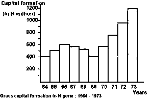
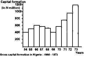
Question 0From the diagram above, the gross capital formation from 1964 t0 1966 wasA.N1500 millionB.N1200 millionC.N900 millionD.N150 millionE.Objective Show full explanation
Question 0The histogram above shows a steady growth of gross capital formation occurred betweenA.1967 and 1971B.1964 and 1968C.1969 and 1973D.1966 and 1970E.Objective Show full explanation
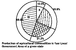
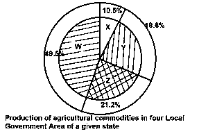
Question 0Express the agricultural production of Y in degrees.A.57oB.67oC.37oD.47oE.Objective Show full explanation
Question 0The diagram is aA.pie chartB.chloropeth mapC.proportional graphD.bar graphE.Objective Show full explanation
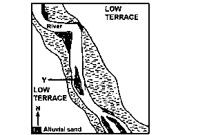
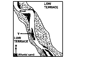
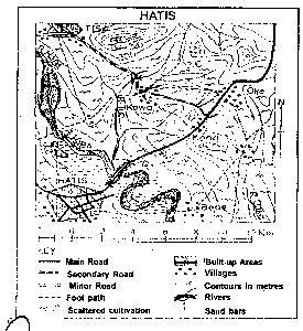
Question 0What pattern of flow did the river develop towards the southern edge of the mapped area?A.MeanderingB.straightC.BraidingD.RadialE.Objective Show full explanation
Question 0In what stage of development is the river?A.Late youthB.Old ageC.Early youthD.Maturity ageE.Objective Show full explanation
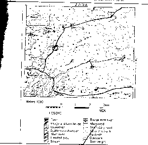
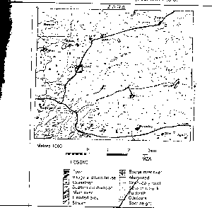
Question 0The height of the point marked X is approximatelyA.572mB.582mC.592mD.562mE.Objective Show full explanation
Question 0All the settlements are locatedA.On top of hillsB.Away from the flood plainsC.On steep slopesD.On the floodplainsE.Objective Show full explanation
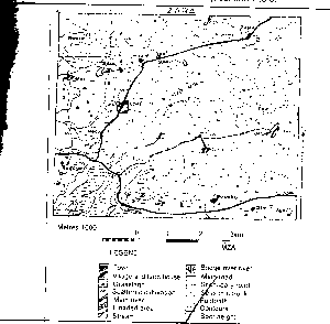
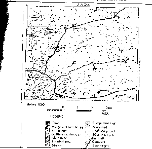
Question 0Zara town is located in theA.SoutheastB.SouthwestC.NortheastD.NorthwestE.Objective Show full explanation
Question 0The two likely occupations in the area are fishing andA.LumberingB.ManufacturingC.MiningD.FarmingE.Objective Show full explanation
Question 0The distance by road from Zara to Lime is approximatelyA.4kmB.6kmC.10kmD.8kmE.Objective Show full explanation