Question 0A map with a scale of 1:40 000 is reduced to one quarter of its size , what is the new scale?A.1:10 000B.1:50 000C.1:160 000D.1:200 000E.Objective Show full explanation
Question 0An instrument used for setting out right angle in surveying a parcel of land is?A.a ranging poleB.an optical squareC.a measuring rodD.Abney levelE.Objective Show full explanation
Question 0An example of a great circle is?A.the equatorB.the earthC.latitude 66 1\2D.latitude 23 1/2E.Objective Show full explanation
Question 0A metamorphosed form of shale is?A.slateB.marbleC.quartziteD.gneissE.Objective Show full explanation
Question 0Sandstone can be classified as?A.argillaceousB.calcareousC.carbonaceousD.aranaceousE.Objective Show full explanation
Question 0A Karst feature in its advanced stage of development is?A.terra rosaB.Sink holeC.Karst valleyD.Karst windowE.Objective Show full explanation
Question 0the common features of the middle course of a river are?A.U-shaped valley and flood plainsB.V-shaped valley and rapidsC.broad interfluves and distributariesD.interlocking spurs and meandersE.Objective Show full explanation
Question 0A form of chemical weathering is?A.fragmentationB.exfoliationC.carbonationD.shatteringE.Objective Show full explanation
Question 0Ocean currents affects the coast they wash when?A.prevailing winds are offshoreB.prevailing winds are onshoreC.there are no prevailing windsD.the ocean floods the shoreE.Objective Show full explanation
Question 0Wind vane is used to record the?A.speed of the windB.type of windC.force of the windD.direction of the windE.Objective Show full explanation
Question 0What is the climate of a station with an annual rainfall of 2650mm spread fairly all year round a mean annual temperature of 27°C?A.Tropical wet-and-dryB.Tropical monsoonC.Tropical humidD.Mediterranean woodlandE.Objective Show full explanation
Question 0Which of the following types of vegetation is characterized by acidic soils?A.Sahel SavannaB.Coniferous forestC.Temperate grasslandD.SteppeE.Objective Show full explanation
Question 0When both the macropores and the micropores are filled with water, the soil is?A.leachedB.at field capacityC.water loggedD.erodeilE.Objective Show full explanation
Question 0A mature soil with distinct horizons occurring in a particular climate zone, but influenced strongly by topography is?A.zonal soilB.intrazonal soilC.azonal soilmD.alluvial soilE.Objective Show full explanation
Question 0Which of the following resources is non-renewable?A.Wind energyB.Solar energyC.Hydro energyD.Nuclear energyE.Objective Show full explanation
Question 0The introduction of materials that have negative impacts on the ecosystem is known as?A.pollutionB.combustionC.transpirationD.evaporationE.Objective Show full explanation
Question 0An example of a climatic hazard is?A.volcanic eruptionB.earthquakeC.hurricaneD.coastal erosionE.Objective Show full explanation
Question 0In which of the following regions is high population density attributable to agricultural development?A.The RhurB.The Nile BasinC.The Amazon BasinD.The Midlands of EnglandE.Objective Show full explanation
Question 0Which of the following statements best describes the population of Southeast Asia?A.High density and high growth rateB.High density and low growth rateC.Low density and high growth rateD.Low density and low growth rateE.Objective Show full explanation
Question 0Which of the following population characteristics is associated with developed countries?A.Declining birth rate and high death rateB.High brith rate and declining death rateC.High brith rate and low death rateD.Low brith rate and low death rateE.Objective Show full explanation
Question 0Urban settlements mainly engage in?A.primary economic activitiesB.secondary economic activitiesC.tertiary economic activitiesD.quaternary economic activitiesE.Objective Show full explanation
Question 0Lagos Sydney, Singapore, Hong Kong and Calabar are cities which have attained considerable importance because they?A.are cross roads to international airlinesB.have seaportsC.are densely populatedD.are administrative capitalsE.Objective Show full explanation
Question 0Which of the following arranges the settlement types in descending order in terms of complexity of functions?A.Metropolis, city, town, village and hamletB.Metropolis, town, city, hamlet and villageC.Metropolis, city, village and hamlet and villageD.Hamlet, village, town, city and metropolisE.Objective Show full explanation
Question 0Which of the following economic activities are classified as primary?A.Farming, transportation, fishing and manufacturingB.Lumbering, banking, transportation and farmingC.Fishing, lumbering, farming and miningD.Mining, trading, farming and lumberingE.Objective Show full explanation
Question 0When manufacturing enterprises produces goods which form raw materials for other enterprises, it is referred to as?A.value addedB.sub-contractingC.forward linkageD.backward linkageE.Objective Show full explanation
Question 0Most less developed nations are trade debtors because?A.of their continuous link with colonial mastersB.of the gross inbalance in international tradeC.they import manufactured goods from industrialized nationsD.their currencies are weakE.Objective Show full explanation
Question 0Large-scale wheat production is associated with the?A.Kano Plains and Ghezira plainsB.Ghezira Plains and Pampas of ArgentinaC.Praires of North America and the Pampas of ArgentinaD.Ganges Plains and the Pampas of ArgentinaE.Objective Show full explanation
Question 0Liberia, Malaysia and Indonesia are known for the production of?A.cocoaB.rubberC.coffeeD.teaE.Objective Show full explanation
Question 0The major means of transportation of goods from the Rhine industrial region to other European cities is by?A.waterwaysB.roadC.airD.railE.Objective Show full explanation
Question 0The Mediterranean fruits are exported mainly to Western Europe rather than Africa because?A.Africa produces more fruits than the Mediterranean regionB.Europe is closer to the Mediterranean than most parts of AfricaC.transport facilities between Africa and Western Europe are betterD.there is higher demand for fruit in Western than in AfricaE.Objective Show full explanation
Question 0The contribution of agriculture to Nigeria's GDP has remained largely low owing to?A.low price of agricultural produceB.lack of access to marketsC.its predominantly subsistence natureD.inadequate labour supplyE.Objective Show full explanation
Question 0A boat building industry is least likely to be situated in?A.Taraba stateB.Kogi stateC.Kano stateD.Kebbi stateE.Objective Show full explanation
Question 0In Nigeria, bays and headlands are features associated with the?A.Southern CoastlandsB.North Central HighlandsC.Sokoto PlainsD.Eastern ScarplandE.Objective Show full explanation
Question 0The population clusters in Kano, Kaduna and Zaira cities in Northern Nigeria in the 1960's are best explained by?A.cultural factorsB.favourable climate conditionsC.the existence of major cash cropsD.the presence of industrial employmentE.Objective Show full explanation
Question 0Nguru and Kaura Namoda settlements in Northern Nigeria are most notable for?A.high production centres for groundnutsB.terminal points for railway tranportationC.towns with the worst problems of water scarcityD.quarrying settlementsE.Objective Show full explanation
Question 0The scattered settlement pattern of the Tiv of the Middle Belt is owing to the?A.security situation in the regionB.agricultural practices to the regionC.directives of its political leadersD.religious beliefs of the peopleE.Objective Show full explanation
Question 0In East Africa, more variety of crops are grown than in West Africa because of?A.different soil typesB.moderate rainfallC.different ranges of altitudeD.different agricultural systemsE.Objective Show full explanation
Question 0Which of the following Africa countries is landlocked?A.ZambiaB.GabonC.SudanD.MozambiqueE.Objective Show full explanation
Question 0The relief system in East Africa is characterized by?A.ridgeB.basinC.rift valleysD.escarpmentE.Objective Show full explanation
Question 0Improved agricultural production in Cote d'Ivoire is mainly due to?A.abundant and relief rainfallB.good and effective transportation routesC.availability of migrant labourD.good organization and effective managementE.Objective Show full explanation
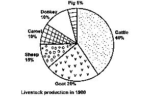
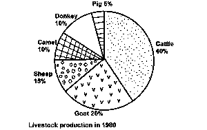
Question 0If the total number of livestock is 6 million, what is the number of cattle producedA.2,200,000B.2,300,000C.2,400,000D.2,500,000E.Objective Show full explanation
Question 0The total number of pigs, camels and donkeys isA.1,600,000B.1,500,000C.1,400,000D.1,300,000E.Objective Show full explanation
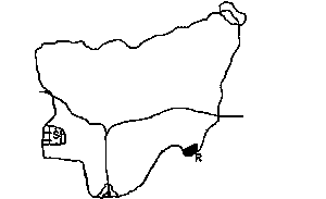
Question 0The area marked S isA.Western troughB.Western uplandC.Obudu plateauD.Oban hillsE.Objective Show full explanation
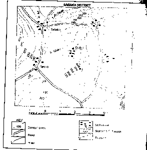
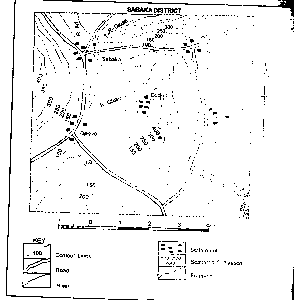
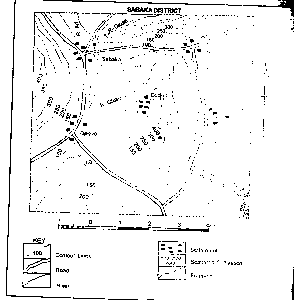
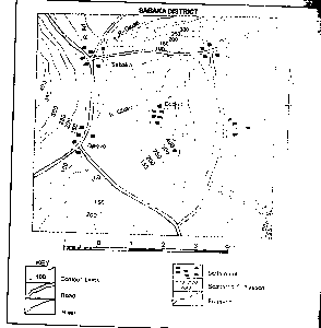
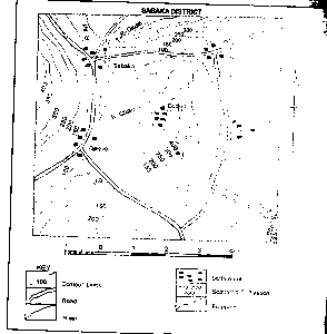
Question 0The Inhabitants of Abu are most likely to beA.TradersB.FarmersC.Cattle rearersD.MinersE.Objective Show full explanation
Question 0The distribution of settlements in the area is mostly influenced byA.DrainageB.VegetationC.ReliefD.Mineral depositsE.Objective Show full explanation
Question 0The area can be described as aA.Low plainB.Rugged reliefC.Flood plainD.PlateauE.Objective Show full explanation
Question 0The features shown North of Abu isA.A spurB.A colC.A ridgeD.An embankmentE.Objective Show full explanation
Question 0The area shaded R isA.Shebshi MountainsB.Biu PlateauC.Adamawa PlateauD.Atlantic MountainsE.Objective Show full explanation