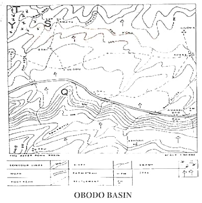
Question 1Study the map of DUBUNDE COUNTY and answer Questions 1 — 5. The area marked M in the North is a ___.A.WaterShedB.PassC.KnollD.EscarpmentObjective Show full explanation
Question 2Study the map of DUBUNDE COUNTY and answer Questions 1 — 5. Line Y in the map is a typical example of ____.A.PassB.Steep slopeC.Gentle slopeD.InselbergObjective Show full explanation
Question 3Study the map of DUBUNDE COUNTY and answer Questions 1 — 5. The general topography of the area is a good example of a / anA.flooded landB.embankmentC.rugged reliefD.market settlementObjective Show full explanation
Question 4Study the map of DUBUNDE COUNTY and answer Questions 1 — 5. The most appropriate approximate bearing of "S" from "B" is ____.A.50B.NNEC.SSWD.None of the aboveObjective Show full explanation
Question 5Study the map of DUBUNDE COUNTY and answer Questions 1 — 5. Symbol Q on the map is placed on a ____.A.hillB.saddleC.plateauD.KnollObjective Show full explanation
Question 6Which of the following differentiates between folds and faultsA.folds is a result of compressional forces but faults are associated with cracks or-fracturesB.folds takes place when the crust cracks and faults are the result of direct forceC.folds are the causes of block mountains while faults cause volcanoD.None of the aboveObjective Show full explanation
Question 7The most outstanding feature of an equatorial climate is ___.A.its great uniformity of temperature throughout the yearB.lack of rainfall to supply luxuriant vegetation growthC.lack of cloud cover almost throughout the yearD.None of the aboveObjective Show full explanation
Question 8An occurrence of volcanoes is closely related to regions that have been intensely ___.A.cultivatedB.floodedC.erodedD.foldedObjective Show full explanation
Question 9Which of the following landforms results from wind depositionA.AreteB.BajadaC.BarchanD.FamObjective Show full explanation
Question 10A depression between two hills that enhances communicationA.rift valleyB.a knollC.a saddleD.a passObjective Show full explanation
Question 11The erosive power of a strong wind is reduced when the ___.A.soil is not covered by vegetationB.soil is dryC.land is overgrazedD.soil is wetObjective Show full explanation
Question 12In a forested region, one human activity likely to be embarked on is ___.A.miningB.fishingC.lumberingD.All of the aboveObjective Show full explanation
Question 13Physical factors affecting the distribution of vegetation include all of the following except ___.A.soil nutrientB.Human beingsC.daylightD.waterObjective Show full explanation
Question 14A place where water enters the ground is called ___.A.water rechargeB.water dischargeC.water sourceD.underground waterObjective Show full explanation
Question 15A river carries its load by ___.A.tractionB.saltationC.suspensionD.All of the aboveObjective Show full explanation
Question 16A station where weather elements are studied and recorded is called ___.A.Train stationB.Air stationC.Weather stationD.Geography stationObjective Show full explanation
Question 17An instrument used for measuring the direction of the wind is called ___.A.BarometerB.WindsockC.Wind hookD.ThermometerObjective Show full explanation
Question 18The study of the atmospheric conditions of a place over a given period is called ___.A.AstronomyB.WeatherC.ClimateD.ResearchObjective Show full explanation
Question 19The best way to prevent a watershed from degradation is through ___.A.interbasin transferB.forest reservationC.crop productionD.fuelwood extractionObjective Show full explanation
Question 20Some of the physical properties of soil are ___.A.texture, structure and porosityB.nutrients, acidity and colourC.structure, colour and alkalinityD.nutrients, acidity and textureObjective Show full explanation
Question 21In Geography, action space simply means ___.A.industrial spaceB.marketing spaceC.awareness spaceD.universal spaceObjective Show full explanation
Question 22One of the following is the dominant staple food grown widely in S. E. AsiaA.SorghumB.RiceC.YarnD.WheatObjective Show full explanation
Question 23Fog is formedA.when very moist air cooled below its dew-pointB.during a clear dry dayC.as a result of lightningD.None of the aboveObjective Show full explanation
Question 24All of the following are effects of earth rotation, except:A.lightB.air motionC.heatD.pollutionObjective Show full explanation
Question 25One of the following is not directly related to population studiesA.the balance between males and femalesB.size of populationC.the ratio of adults to childrenD.growth of towns and villagesObjective Show full explanation
Question 26Which of the following regions has the highest population density in Nigeria?A.Western regionB.West-CentralC.North-CentralD.East CentralObjective Show full explanation
Question 27Which of the following theories explains the relationship between population and subsistence.A.the demographic transition theoryB.the migratory push-pull theoryC.the Malthusian theoryD.the gravity theoryObjective Show full explanation
Question 28The largest city in Europe is ___.A.ParisB.LondonC.BerlinD.Moscow Objective Show full explanation
Question 29The largest city in Africa south of the Sahara is ___.A.CairoB.lbadanC.JohannesburgD.KinshasaObjective Show full explanation
Question 30The most populated city in the world with over a million inhabitants is ___.A.TokyoB.GlasgowC.MoscowD.ManchesterObjective Show full explanation
Question 31The main advantage of plane tabling as a survey method is that it ___.A.is a fast methodB.gives accurate results in most situationsC.is an all-weather methodD.requires little or no skill to useObjective Show full explanation
Question 32Bees and butterflies are important to flowering plants because theyA.pollinate the plantsB.satisfy human needsC.produce honeyD.extract excess nectarObjective Show full explanation
Question 33A depositional land-form occurring where streams emerge from a mountain area in a desert is ___.A.a self duneB.a playa lakeC.a rock pedestalD.an alluvial fanObjective Show full explanation
Question 34The prairies of North America areA.montane grasslandsB.temperate desertsC.tropical grasslandsD.temperate grasslandsObjective Show full explanation
Question 35The Stevenson's screen is raised about one metre above the ground in order to avoid ___.A.raindrops entering itB.the influence of strung whirsC.the effects of nearby treesD.the heat from the groundObjective Show full explanation
Question 36The variable which is both a control and an element of weather and climate is ___.A.windB.air-massC.temperatureD.rainfallObjective Show full explanation
Question 37The greatest threat to the world's wildlife population is ___.A.the poor management of game reservesB.the development of zoological gardensC.excessive hunting D.the destruction of habitatsObjective Show full explanation
Question 38The formation of coal is associated with ___.A.landslide and depositionB.earth movement and pressureC.heat and pressureD.earth tremor and heatObjective Show full explanation
Question 39A hazard that could be traced directly to ozone layer depletion is theA.escalation of the melting, of polar and temperate ice capsB.introduction of ultraviolet rays into the troposphereC.submergence of numerous coastal settlements in the worldD.extension of desert-like conditions to the savannaObjective Show full explanation
Question 40An example of a land-form produced by glaciations is ___.A.a cirqueB.a sand-duneC.an ox-bow lakeD.an inselbergObjective Show full explanation