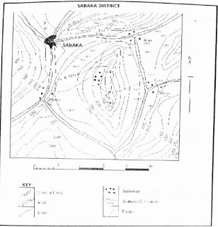
Question 1Study the Map of SABAKA District and answer Questions 1 – 5 The inhabitants of Abu are most likely to be_____A.tradersB.farmersC.cattle herdersD.minersObjective Show full explanation
Question 2Study the Map of SABAKA District and answer Questions 1 – 5 The distribution of settlements in the areas is mostly influenced by_____A.drainageB.vegetationC.reliefD.mineral depositsObjective Show full explanation
Question 3Study the Map of SABAKA District and answer Questions 1 – 5 The spot height on the map isA.320mB.360mC.400mD.440mObjective Show full explanation
Question 4Study the Map of SABAKA District and answer Questions 1 – 5 The map area can be described as a_____A.low plainB.rugged reliefC.flood painD.PlateauObjective Show full explanation
Question 5Study the Map of SABAKA District and answer Questions 1 – 5 The feature shown North of Abu is_____A.a spurB.a colC.a ridgeD.an escarpmentObjective Show full explanation
Question 6Which type of energy uses magma or hot dry rocks to generate electricity?A.geothermalB.hydroelectricC.nuclearD.solarObjective Show full explanation
Question 7Which is an inexhaustible resource?A.coalB.nuclearC.oilD.solarObjective Show full explanation
Question 8Which helps to reduce the demand for new mineral resources?A.generatingB.recyclingC.miningD.refiningObjective Show full explanation
Question 9Which type of map shows elevation at earth's surface?A.mercatorB.robinsonC.conicD.topographicObjective Show full explanation
Question 10The projection that shows accurate continent and accurate land areas isA.conicB.RobinsonC.topographicD.MercatorObjective Show full explanation
Question 11Land satellite collect data by using_____A.sonarB.sound wavesC.echolocationD.light wavesObjective Show full explanation
Question 12Physical factors affecting the distribution of vegetation include the following except_____A.human beingsB.waterC.daylightD.soil nutrientObjective Show full explanation
Question 13Lines on maps joining together places with the same sunshine amount are called_____A.IsobarsB.IsohelsC.IsothermsD.IsodapanesObjective Show full explanation
Question 14Two examples of inland drainage lakes in Africa are_____A.Lake Chad and Lake EdwardsB.Lake Victoria and Lake NgamiC.Lake Chad and Lake TurkanaD.Lake Malawi and Lake TurkanaObjective Show full explanation
Question 15The highest land in Nigeria is found on the_____A.Mambilla PlateauB.Oban HillsC.North Central PlateauD.Western HighlandsObjective Show full explanation
Question 16A range of temperature of a given station is?A.the total temperature for the stationB.the difference between the maximum and the minimum temperature for the stationC.maximum temperature for the stationD.None of the aboveObjective Show full explanation
Question 17Which consists of fine-grained wind sediment?A.MoraineB.TillC.LoessD.RockfallObjective Show full explanation
Question 18What is a layer of permeable rock that water flows through?A.caveB.water tableC.a poreD.hot springObjective Show full explanation
Question 19What is the network formed by a river and all the smaller streams that contribute to it?A.groundwater systemB.zone of saturationC.river systemD.water tableObjective Show full explanation
Question 20In which area of the ocean is the greatest source of food build?A.on the abyssal plainB.along continental shelvesC.along the mid-ocean ridgeD.in trenchesObjective Show full explanation
Question 21A period of 24 hours of rain with an amount not below 0.2mm is called_____A.A rainy dayB.A rain timeC.A rain beltD.None of the aboveObjective Show full explanation
Question 22Which of the following statistical mapping techniques is most suitable for Showing the spatial distribution of cattle in the different states of Northern Nigeria?A.isoplethsB.pie chartC.dot mapD.proportional circlesObjective Show full explanation
Question 23The growth of population at a rate faster than the available resources may result in_____A.underpopulationB.ageing populationC.overpopulationD.optimum populationObjective Show full explanation
Question 24The busiest and the most important route that links two of the most populous and heavily industrialized parts of the world is the_____A.Cape routeB.North Atlantic routeC.Panama canal routeD.Trans-pacific routeObjective Show full explanation
Question 25The following are lakes formed by deposition exceptA.lakes due to landslidesB.lakes forming ox-bow lakesC.lakes forming lagoonsD.karst lakesObjective Show full explanation
Question 26Which of the following rivers is not a tributary of the Amazon?A.MadeiraB.TapajosC.NegroD.SalvadoObjective Show full explanation
Question 27Which of the following countries produces all of copper, petroleum, iron ore and diamonds?A.EgyptB.ZimbabweC.AngolaD.TanzaniaObjective Show full explanation
Question 28Which one of the following areas are associated with active volcanoes?A.glaciated uplandsB.plateau surfacesC.newly folded mountainsD.continental plainsObjective Show full explanation
Question 29Among West African countries, Togo is a leading exporter of_____A.coffeeB.sugarC.limestoneD.phosphatesObjective Show full explanation
Question 30Seismic waves from earthquakes are measured with an instrument known as a_____A.seismonologyB.seismothernC.seismographD.seismonomObjective Show full explanation
Question 31What hypothesis states that continents slowly moved to their present positions on earth?A.seafloor spreadingB.subductionC.sub erosionD.continental driftObjective Show full explanation
Question 32In which galaxy does the sun exist?A.Aril's galaxyB.Milky way galaxyC.Bernard's galaxyD.Andromeda galaxyObjective Show full explanation
Question 33Which of the following gives the best description of Lagos? I. cosmopolitan city II. cultural city III industrial city IV. mining townA.I and IV onlyB.I and II onlyC.I and III onlyD.II and IV onlyObjective Show full explanation
Question 34Nature reserves in Africa are managed and utilized for several activities with the exception of_____A.afforestationB.agro-forestryC.ranchingD.tourismObjective Show full explanation
Question 35A rift valley can develop as a result of_____A.heavy rainfall and earthquakeB.volcanic intrusion and avalancheC.parallel faults and tensional forcesD.landslide and slumpObjective Show full explanation
Question 36In which of the following countries is land reclaimed from the sea intensively used for cultivation?A.BelgiumB.EnglandC.FinlandD.RollandObjective Show full explanation
Question 37The leading wheat-producing region of the world is the_____A.Pampas of ArgentinaB.Prairie of North AmericaC.Downs of AustraliaD.Veldt of South AfricaObjective Show full explanation
Question 38A river loses energy and may deposit some of its load if_____A.its bed and banks become smootherB.its discharge increasesC.its gradient decreasesD.it becomes narrow and deepObjective Show full explanation
Question 39Time as a factor of soil formation influences mainly soil_____A.textureB.organismsC.nutrientsD.maturityObjective Show full explanation
Question 40The difference in the readings on the dry and wet bulb thermometers is used to determine.A.atmospheric pressureB.range of temperatureC.evaporationD.relative humidityObjective Show full explanation