Teacha
  • Courses
  • Mock Exams
  • For Tutors
  • For Schools
  • Pricing
Log InStart Free
  1. Past Questions
  2. /
  3. NDA
  4. /
  5. Geography
  6. /
  7. 2017/2018
  8. /
  9. Q1
Question 1


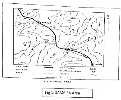
Use the map above to answer questions 1-5
What is the approximate height of the location marked X

  • A.360 metres
  • B.375 metres
  • C.380 metres
  • D.395 metres
Objective

Question details

Exam body
NDA
Subject
Geography
Year
2017/2018
Question no.
#1
Type
Objective
Next · Q2 Use the map above to answer questions 1-5 Name the feature crossed by the…

More from this paper

  • Q3Use the map above to answer questions 1-5 A map measures 10cm by 6cm. If the map…
  • Q4Use the map above to answer questions 1-5 What is the average gradient of the…
  • Q5Use the map above to answer questions 1-5 What is the length of the main road to…
  • Q6Which of the following lines of latitude divides the earth into two hemispheres?
  • Q7The angular distance of a point on the Earth's surface which is measured in…
  • Q8A mercury barometer is used for measuring
See all Geography 2017/2018 questions
Teacha

Africa's learning & exam readiness platform. Built for students, tutors, and schools.

Platform

  • Courses
  • Mock Exams
  • Past Questions

For You

  • I'm a Tutor
  • I'm a School
  • Pricing

© 2025 Teacha. Built for African learners, tutors, and schools. Teacha is not affiliated with WAEC, NECO, or JAMB. All past questions are sourced from publicly available materials.

Privacy PolicyTerms of UseCookie Policy