Teacha
  • Courses
  • Mock Exams
  • For Tutors
  • For Schools
  • Pricing
Log InStart Free
  1. Past Questions
  2. /
  3. WAEC
  4. /
  5. Geography
  6. /
  7. 2015
  8. /
  9. Q7
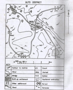
Question 7Question image

What is the contour interval of the map?

  • A.25 metres
  • B.50 metres
  • C.100 metres
  • D.150 metres
Objective

Question details

Exam body
WAEC
Subject
Geography
Year
2015
Question no.
#7
Type
Objective
Previous · Q6What is the settlement of Ede? Next · Q8 Which economic activity could be practiced in the south-eastern part of mapped…

More from this paper

  • Q3Which of the following settlements performs administrative function?
  • Q4In which part of the mapped area is lumbering a likely economic activity?
  • Q5What is the direction of flow of River Afikpo?
  • Q9Which of the following modes of transport is commonly used in the mapped area?
  • Q10The distance by road from Mami to Buto is approximately_____?
  • Q11The hotter planet is____?
See all Geography 2015 questions
Teacha

Africa's learning & exam readiness platform. Built for students, tutors, and schools.

Platform

  • Courses
  • Mock Exams
  • Past Questions

For You

  • I'm a Tutor
  • I'm a School
  • Pricing

© 2025 Teacha. Built for African learners, tutors, and schools. Teacha is not affiliated with WAEC, NECO, or JAMB. All past questions are sourced from publicly available materials.

Privacy PolicyTerms of UseCookie Policy