Teacha
  • Courses
  • Mock Exams
  • For Tutors
  • For Schools
  • Pricing
Log InStart Free
  1. Past Questions
  2. /
  3. WAEC
  4. /
  5. Geography
  6. /
  7. 2016
  8. /
  9. Q6
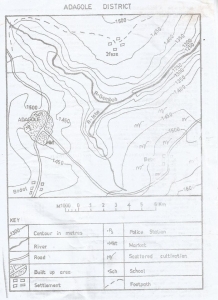
Question 6Question image

The lowest point in the map is in the

  • A.South-east
  • B.North-east
  • C.South-west
  • D.North-west
Objective

Question details

Exam body
WAEC
Subject
Geography
Year
2016
Question no.
#6
Type
Objective
Previous · Q5The contour interval on the map is Next · Q7 The distance as the crow flies from Bebe to Bodel is

More from this paper

  • Q2Farming is common in
  • Q3The western part of R. Gembeh flows through
  • Q4The point where R.Isbo meets R.Gembeh is called
  • Q8The bearing of Bodel from Bebe is
  • Q9Which of the following statements is true about the drainage of the mapped area?
  • Q10The common modes of transportation in the mapped area are
See all Geography 2016 questions
Teacha

Africa's learning & exam readiness platform. Built for students, tutors, and schools.

Platform

  • Courses
  • Mock Exams
  • Past Questions

For You

  • I'm a Tutor
  • I'm a School
  • Pricing

© 2025 Teacha. Built for African learners, tutors, and schools. Teacha is not affiliated with WAEC, NECO, or JAMB. All past questions are sourced from publicly available materials.

Privacy PolicyTerms of UseCookie Policy