Teacha
  • Courses
  • Mock Exams
  • For Tutors
  • For Schools
  • Pricing
Log InStart Free
  1. Past Questions
  2. /
  3. WAEC
  4. /
  5. Geography
  6. /
  7. 2017
  8. /
  9. Q8
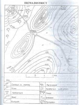
Question 8Question image

Which of the following best explains the growth of IREWA?

  • A.Nodal town
  • B.Centre of plantation agriculture
  • C.Good climate
  • D.Industrial town
Objective

Question details

Exam body
WAEC
Subject
Geography
Year
2017
Question no.
#8
Type
Objective
Previous · Q7The most likely occupation of the people of Oki is Next · Q9 The most probable reason for the construction of the road from IREWA through…

More from this paper

  • Q4The symbol A950 to the north-east of IREWA is
  • Q5The feature marked H on the map can best be described as a
  • Q6Which of the following settlements is located at the highest altitude?
  • Q10Which of the following towns may not be visible from the feature marked H?
  • Q11Which of the following methods of representing statistical data would be most…
  • Q12Which of the following types of bar graphs shows increases and decreases…
See all Geography 2017 questions
Teacha

Africa's learning & exam readiness platform. Built for students, tutors, and schools.

Platform

  • Courses
  • Mock Exams
  • Past Questions

For You

  • I'm a Tutor
  • I'm a School
  • Pricing

© 2025 Teacha. Built for African learners, tutors, and schools. Teacha is not affiliated with WAEC, NECO, or JAMB. All past questions are sourced from publicly available materials.

Privacy PolicyTerms of UseCookie Policy