Teacha
  • Courses
  • Mock Exams
  • For Tutors
  • For Schools
  • Pricing
Log InStart Free
  1. Past Questions
  2. /
  3. WAEC
  4. /
  5. Geography
  6. /
  7. 2018
  8. /
  9. Q8
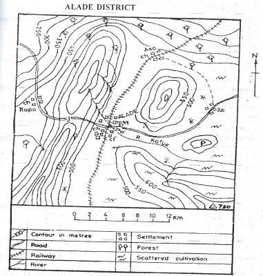
Question 8Question image

What type of settlement is ALADE from the map?

  • A.Nodal
  • B.Coastal
  • C.Dry Valley
  • D.Linear
Objective

Question details

Exam body
WAEC
Subject
Geography
Year
2018
Question no.
#8
Type
Objective
Previous · Q7The northern part of the map above is suitable for Next · Q9 What is the bearing of the trigonometrical station from Ilo on the map above?

More from this paper

  • Q4What is the approximate length of the railway line on the map above?
  • Q5On the map above, R. Kafue takes its source from a
  • Q6The feature marked P on the map above is a
  • Q10The most important settlement in the area is
  • Q11Use the climatic data to answer the question below Month Jan Feb Mar Apr May…
  • Q12Use the climatic data to answer the question below Month Jan Feb Mar Apr May…
See all Geography 2018 questions
Teacha

Africa's learning & exam readiness platform. Built for students, tutors, and schools.

Platform

  • Courses
  • Mock Exams
  • Past Questions

For You

  • I'm a Tutor
  • I'm a School
  • Pricing

© 2025 Teacha. Built for African learners, tutors, and schools. Teacha is not affiliated with WAEC, NECO, or JAMB. All past questions are sourced from publicly available materials.

Privacy PolicyTerms of UseCookie Policy