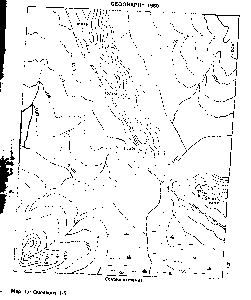
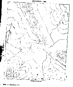
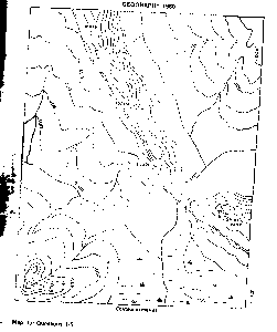
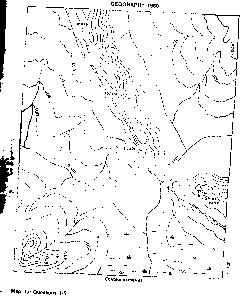
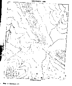
Question 0The true bearing, to the nearest degree of the highest peak in the mapped area from the center of the bridge across River Obe is?A.199°B.239°C.249°D.319°E.339°Objective Show full explanation
Question 0Ketegi settlement is typically aA.scarpfoot settlementB.foot-hill settlementC.wet-point settlementD.dry-point settlementE.confluence settlementObjective Show full explanation
Question 0The feature running across the middle of the mapped area from N.W TO S.E, on which most of the settlements are located, is a (an)A.ridgeB.hillC.escarpmentD.knollE.cuestaObjective Show full explanation
Question 0Which of these is not a likely reason why the only road on the mapped area runs along the elevated feature ?A.it was built to avoid the low, floodable regionB.the road reduced to a minimum the cost of building ridges and culverts across the streamsC.the major settlements are on the elevation and the road connects to themD.the elevation is relatively a low one and so does not constitute an obstacle to road constructionE.There is no other place through which the road could pass except on the elevationObjective Show full explanation
Question 0A ship's radioed message on the high sea at 5.45pm was heard at Abidjan(5°W) at 11.15a.m on the same day.Find the position of the shipA.90E°B.92° 30'EC.95°ED.97° 30'EE.100°EObjective Show full explanation
Question 0What feature would you associate with a rejuvenated river?A.a waterfallB.a deltaC.a meanderD.sand depositsE.a wide u-shaped valleyObjective Show full explanation
Question 0The intensity of the sun's heat is not much in polar regions becauseA.the earth is flat at the polesB.the atmosphere is thick at the polesC.the atmosphere is thin at the polesD.the angle of insolation is lowE.the angle of insolation is highObjective Show full explanation
Question 0Which of the following is a correct pair?A.Glacier/Erratic boulderB.Desert/CavernC.Limestone/PassD.Mountain/StalagmiteE.River/Cut-offObjective Show full explanation
Question 0Which of the following rocks is composed of the skeletons of microscopic sea plants and animals?A.SandstoneB.SlateC.ChalkD.ClayE.GraniteObjective Show full explanation
Question 0Annual rainfall is low and erratic.The vegetation is scanty,although temperature is generally high, yet the daily range of temperature is very high. Which of the following is the climatic type described above?A.MonsoonB.MediterraneanC.British typeD.Hot cool temperate continentalE.Hot desertObjective Show full explanation
Question 0Rain falls mainly during the warm summer months.Summer temperature rarely exceeds 18.3°C.Annual rainfall is often below 125cm.Which of these crops is most unlikely to do well in the area described above?A.WheatB.CottonC.OatsD.RiceE.RyeObjective Show full explanation
Question 0Which of these industries is usually located at the source of its major raw materials?A.cement manufacturingB.brewingC.textile manufacturingD.stone dressingE.shoe manufacturingObjective Show full explanation
Question 0Which one of the following states of Nigeria is a major kola-nut producer?A.KanoB.BornoC.BendelD.BauchiE.BenueObjective Show full explanation
Question 0Nigeria's new federal capital territory shares boundaries with four states.What are these states?A.Benue,Kwara,Niger and KadunaB.Kano,Kaduna,Niger and KwaraC.Plateau,Kwara,Niger and KadunaD.Gongola,Bauchi,Kwara and NigerE.Niger,Benue,Kwara and KanoObjective Show full explanation
Question 0Which are three main export crops of Uganda? 1.Bananas 2.Coffee 3.Cotton 4.Groundnuts 5.Sugar 6.Cassava 7.TobaccoA.1&5&7B.2&3&7C.2&4&5D.1&6&7E.3&4&6Objective Show full explanation
Question 0Which of the following is the least important reason for promoting manufacturing industries by West African Nations?A.to reduce dependence on agricultureB.to earn more foreign exchangeC.to raise the level of employmentD.to increase productivity at the national levelE.to produce locally everything neededObjective Show full explanation
Question 0Which of the geographical reasons below least supports the existence of ECOWAS?A.the countries in the community are contiguousB.it has an internal market of about 160million peopleC.the peoples are of the same racial groupD.the products are complementaryE.the countries in the community share similar physical characteristicsObjective Show full explanation
Question 0Dodoma is to Tanzania as .........is to NigeriaA.LagosB.AbujaC.Port HacourtD.AjaokutaE.WarriObjective Show full explanation
Question 0What is the cause of the double rainfall maximal in southern Nigeria?A.land and sea breezesB.nearness to the atlantic oceanC.overhead sun at the tropic of CancerD.North and South movement of the overhead sunE.overhead sun on the equatorObjective Show full explanation
Question 0Textile industries in Nigeria are characterized by the following features except one?A.full automationB.import substitutionC.labour intensiveD.market orientedE.raw material orientedObjective Show full explanation
Question 0The following is a description of a type of climate:'very cold winters(-34°C or colder), hot summers (21°C); mean annual rainfall under 380mm,most of it occurring in summer'. To which of the following does the description relate?A.tropical continentalB.tropical monsoonC.temperate western marginD.temperate continentalE.temperate eastern marginObjective Show full explanation
Question 0which of the following features is NOT characteristics of a glaciated area?A.Hanging valleysB.AretesC.Interlocking spursD.U-shaped valleysE.FjordsObjective Show full explanation
Question 0Which one of the following terms give us the best general description of the relief of West Africa?A.Swamps and low landsB.Hills and mountainC.Scarp slopes and deep slopesD.plain and plateauxE.Flood plainsObjective Show full explanation
Question 0which of the following is the most important reasons why the highest densities of cattle in West Africa are to be found in the Sudan and Sahel Savannah zones?A.The two zones are far from the coastB.The two zones have abundant water resourcesC.The two zones have abundant fodder resoucesD.the two zones are largely free from tsetse fliesE.The two zones have moderate temperatureObjective Show full explanation
Question 0which of the following countries have few resources and yet has develop industries tremendously?A.United kingdomB.ItalyC.FranceD.NorwayE.SwitzalandObjective Show full explanation
Question 0Which among the following is a producer of coal?A.Wankie (Zimbabwe)B.Ndola (Zambia)C.Nsutta (Ghana)D.Jos (Nigeria)E.Marampa (Sierra Leone)Objective Show full explanation
Question 0Which of these is the least important advantage of the transcontinental railways in Europe and North-America?A.Easy evacuation of mineral productsB.Political integrationC.Easy evacuation of agricutural productsD.Promotion of industrial activitiesE.Employment of labourObjective Show full explanation
Question 0Which of the following can be regarded as the backbone of a modern industrial economy?A.Cement manufacturing industryB.Ship-Building industryC.Motor vehicle manufacturing industryD.Textiloe industryE.Iron and Steel industryObjective Show full explanation
Question 0A hinterland is?A.the central part of a countryB.an area which is far from the coastC.a landlocked countryD.an area surrounding a cityE.the area which is served by a portObjective Show full explanation
Question 0very large in area but very low in population;which of the following countries fits this description best?A.LesothoB.TunisiaC.NigeriaD.ZaireE.BurundiObjective Show full explanation
Question 0The industrial economy of South-Africa is NOT based on one of the following factors:A.abundant coal resourcesB.abundant crude petroleum resourcesC.abundant agricultural resourcesD.abundant cheap labourE.Large-scale investment by such countries like West Germany,the U.S.A and United Kingdom.Objective Show full explanation
Question 0Volcanoes are considered a natural resource because of all but one of the following reasonA.mountainous landscape of volcanic origin have more scenic beautyB.most volcanic soils yield fertile soilsC.intrusive volcanoes somtimes contains economic mineralsD.volocanic explosion helps control world populationE.most volcanic rocks are good sources of structural materials like building stonesObjective Show full explanation
Question 0which of these sets best arranges these settlement types in ascending order in terms of their complexity of function?A.hamlet,village,town,city,metropolisB.village,hamlet,city,town,metropolisC.metropolis,town,city,village,hamletD.town,hamlet,village,city,metropolisE.metropolis,city,town,village,hamletObjective Show full explanation
Question 0the great agricultural regions of the world includes all but one of theseA.the corn belt of USAB.the pampas of ArgentinaC.the Black soils Region of UkraineD.the High Veldt of South AfricaE.the Sahel of West AfricaObjective Show full explanation
Question 0which of these sea routes carries the heaviest traffic?A.the North Atlantic routes between europe and North AmericaB.the Suez Canal route between Europe and AsiaC.the Cape route between Europe and ASIAD.the Panama Canal route between Europe and ASIAE.the Atlantic route between North America and West AfricaObjective Show full explanation
Question 0the Nigerian petroleum refineries are located at one of the following pairs of town?A.Lagos and Port-HarcourtB.Port-Harcourt and CalabarC.Benin and WarriD.Calabar and KadunaE.Port-Harcourt and WarriObjective Show full explanation
Question 0Nigeria's proposed Iron and steel industry based on the direct reduction would be located at;A.OSHOGBOB.Port-HarcourtC.EnuguD.WarriE.Objective Show full explanation
Question 0Vegetables are usually grown near markets or their places of consumption because?A.they are easily perishableB.they are not susceptible to attack from pestsC.they are meant to be eaten mainly by town dwellersD.they can withstand heat for a long timeE.they are bulky and weight gaining in transitObjective Show full explanation
Question 0Industries can be classified as either light or heavy. Which of the following groups of industries can be classified as light?A.Textile, clothing, footwear and printingB.Iron and steel, cement and sugarC.N0n-metalic products an chemicalsD.Petroleum, sugar and block-makingE.Objective Show full explanation
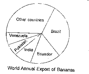
Question 0From the above diagram, Brazil's contribution to the export of bananas isA.60%B.50%C.30%D.20%E.10%Objective Show full explanation
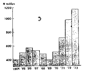
Question 0Gross capital formation in Nigeria 1964-1973, what can be inferred from the histogram above?A.there was a steady growth of capital formation in the periodB.capital formation in the last two years exactly equalled those of all previous years combinedC.at the end of the period, Nigeria had become self-sufficientD.Nigeria experienced serious economic problems during the periodE.Nigeria is one of the richest countries in AfricaObjective Show full explanation
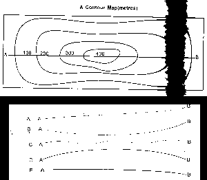
Question 0Which of the following is the appropriate shape of the section from A to B? choose the correct answer from the options aboveA.AB.BC.CD.DE.EObjective Show full explanation
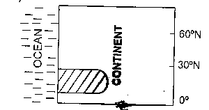
Question 0Identify the shaded natural region in the diagramA.Tropical monsoonB.EquatorialC.Hot desertD.MediterraneanE.Tropical savannahObjective Show full explanation
Question 0The ground distance along the river from the confluence of Rivers Obe and Opi to the bridge across River Obe is 5.5kilometres. What is the scale of the map in Representative Fraction?A.1:10,000B.1:50,000C.1:100,000D.1:500,000E.1:1,000,000Objective Show full explanation
Question 0Which one of the following states of Nigeria is a major cotton producer?A.KanoB.BornoC.BendelD.BauchiE.BenueObjective Show full explanation
Question 0Which of these statements is true of Africa?A.Africa is the fourth largest continent in the worldB.Africa is the least urbanized continentC.Tropical Africa is so warm that nowhere within it can find snow or iceD.There are no more than ten land-locked countries in AfricaE.Africa produces nearly all the world's hard-wood timber.Objective Show full explanation
Question 0Explain the increasing importation of food to West Africa countriesA.Bad soils which cannot produce enough foodB.Progressive neglect of food productionC.Unfavourable climates for enough food productionD.Too large populations which cannot be satisfied locallyE.People's love for imported foodsObjective Show full explanation
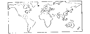
Question 0Which one of the areas shaded on the world map above is not an area of high population?A.1B.2C.3D.4E.5Objective Show full explanation
Question 0Which of the following best interprets the scale "1cm represents 1km?A.1:50 000B.1:300 000C.1:12 000D.1/80 000E.1:100 000Objective Show full explanation
Question 0The climatic data shown above are for a representative station in one of the following climatic types?A.Tropical wet climateB.Mediterranean climate or sub-tropical dry summerC.Tropical wet and dry climate or savannahD.Temperate oceanic climateE.Sub-tropical steppe(semi-desert) climateObjective Show full explanation