Teacha
  • Courses
  • Mock Exams
  • For Tutors
  • For Schools
  • Pricing
Log InStart Free
  1. Past Questions
  2. /
  3. JAMB
  4. /
  5. Geography
  6. /
  7. 1980
  8. /
  9. Q0
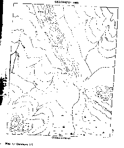
Question 0Question image

The ground distance along the river from the confluence of Rivers Obe and Opi to the bridge across River Obe is 5.5kilometres. What is the scale of the map in Representative Fraction?

  • A.1:10,000
  • B.1:50,000
  • C.1:100,000
  • D.1:500,000
  • E.1:1,000,000
Objective

Question details

Exam body
JAMB
Subject
Geography
Year
1980
Question no.
#0
Type
Objective
Previous · Q0Identify the shaded natural region in the diagram Next · Q0 Which one of the following states of Nigeria is a major cotton producer?

More from this paper

  • Q0The true bearing, to the nearest degree of the highest peak in the mapped area…
  • Q0Ketegi settlement is typically a
  • Q0The feature running across the middle of the mapped area from N.W TO S.E, on…
  • Q0Which of these is not a likely reason why the only road on the mapped area runs…
  • Q0A ship's radioed message on the high sea at 5.45pm was heard at Abidjan(5°W) at…
  • Q0What feature would you associate with a rejuvenated river?
See all Geography 1980 questions
Teacha

Africa's learning & exam readiness platform. Built for students, tutors, and schools.

Platform

  • Courses
  • Mock Exams
  • Past Questions

For You

  • I'm a Tutor
  • I'm a School
  • Pricing

© 2025 Teacha. Built for African learners, tutors, and schools. Teacha is not affiliated with WAEC, NECO, or JAMB. All past questions are sourced from publicly available materials.

Privacy PolicyTerms of UseCookie Policy