Question 0On the scale of 1: 12,500 converted to a statement scale, one centimeter would represent?A.0.125kmB.1.25.00kmC.2.500kmD.12.500kmE.125.000kmObjective Show full explanation
Question 0If a map has a scale of 1:50,000 and oil palm plantation is represented on the map by a rectangle 4cm by 3cm, what is the area of the plantation?A.3sq. kmB.4sq. kmC.12sq.kmD.20sq.kmE.25sq.kmObjective Show full explanation
Question 0A map with a scale of 1:40,000 is reduced to one quarter of its size, what is the new scale of the map?A.1:20,000B.1:40,000C.1:60,000D.1:80,000E.1:100,000Objective Show full explanation
Question 0An international football match is scheduled to start at 4.45p.m local time in Alexandria, Egypt, which lies on Longitude 30°E. What will be the local time at Bouake, Ivory Coast, on Longitude 5°W?A.2.05 p.mB.2.22 p.mC.2.45 p.mD.6.45p.mE.7.05 p.mObjective Show full explanation
Question 0Which of the following is NOT a sedimentary rock?A.slateB.coalC.clayD.sandE.shaleObjective Show full explanation
Question 0A river DOES NOT erode its bed by?A.attritionB.corrasionC.solutionD.pot - holingE.hydraulic actionObjective Show full explanation
Question 0A deflation hollow is produced by?A.glacial erosionB.wave erosionC.wind erosionD.solutionE.river erosionObjective Show full explanation
Question 0Which of the following landforms is NOT due tot he process of glacial erosion?A.Valley-benchB.Hanging valleyC.CorrieD.AreteE.EskerObjective Show full explanation
Question 0The sea with the highest degree of salinity in the world is the?A.Caspian SeaB.Dead SeaC.Mediterranean SeaD.Baltic SeaE.Red SeaObjective Show full explanation
Question 0Adiabatic cooling' is the cooling of rising air as a result of?A.increase altitudeB.expansion and internal loss of heatC.movement on the windward side of mountainsD.instabilityE.advectionObjective Show full explanation
Question 0If the temperature at sea level at the foot of Cameroon Mountain is 32°C, what is the temperature at the summit which is 4,000m above sea level given an environmental lapse rate of sea level given environmental lapse rate of 0.65°C of 100cm?A.-2°CB.4°CC.6°CD.8°CE.10°CObjective Show full explanation
Question 0In which of these continents is there no true desert?A.North AmericaB.AustraliaC.EuropeD.AsiaE.South AmericaObjective Show full explanation
Question 0The pair of countries which has the largest area of coniferous forest in the world is made up of Canada and?A.the U.S.AB.NorwayC.the U.S.S.RD.BrazilE.New ZealandObjective Show full explanation
Question 0Pulp-wood, which is used in the manufacturing of paper, cardboard and cellulose, is derived mainly from?A.coniferous forestsB.tropical rain forestsC.savannah woodlandsD.desert plantsE.broad-leaved forestsObjective Show full explanation
Question 0Which of these geographical phenomena is found only in the Northern Hemisphere?A.Tropical rain forestB.Mediterranean woodlandC.Hot desert oasisD.Tundra vegetationE.Coniferous forestObjective Show full explanation
Question 0The term 'catena' describes the?A.effect of topography on soil seriesB.sequence of modified soil along a slope profileC.changes in soil fertility along a slope profileD.group of soil on sedimentary rocksE.colour differences in soils along slope profileObjective Show full explanation
Question 0Which of the following major soils types is found in the Savannah areas of Nigeria?A.PodzolsB.Ferralitic red soilsC.ChernozemsD.Ferruginous tropical soilsE.Brown earthsObjective Show full explanation
Question 0Which of the following types of vegetable is characterized by acidic soils?A.SteppeB.Sahel savannaC.Coniferous forestD.Temperate grasslandE.DesertObjective Show full explanation
Question 0Which of the following is NOT applicable when describing desert soils?A.High acidityB.Poorly developed horizonsC.Shallow depthsD.High alkalinityE.Coarse textureObjective Show full explanation
Question 0The population density of a country is calculated on the basis of the?A.rate of population increaseB.birth rate and the the death rateC.number of people migrating to the countryD.size of the country in relation to the populationE.number of people living in the townsObjective Show full explanation
Question 0ONE area which carries a very high density of rural population is the?A.Amazon basinB.Scandinavian group of countriesC.SudanD.Ganges ValleyE.South-east of AustraliaObjective Show full explanation
Question 0Low birth rate and low death rate are characteristics of?A.BrazilB.IndianC.NigeriaD.MexicoE.The United KingdomObjective Show full explanation
Question 0A nucleated settlement differs from a dispersed settlement in that it?A.usually occurs at the meeting point of several roadsB.often occurs in adensely populated areaC.is usually found in a forest areaD.is compactE.contains more peopleObjective Show full explanation
Question 0Although the rubber tree is a native of Brazil most of the world's natural rubber is now produced in?A.BurmaB.ColombiaC.NigeriaD.ZaireE.MalaysiaObjective Show full explanation
Question 0The three most important grain crops of the world are?A.guinea corn, millet and riceB.wheat, rice and milletC.rice, wheat and maizeD.rice, millet and maizeE.rice, wheat and guinea cornObjective Show full explanation
Question 0ONE region which is known for large-scale production of wheat is the?A.Veld of South AfricaB.Hwang Ho ValleyC.UkraineD.Paris BasinE.London BasinObjective Show full explanation
Question 0Which of the following countries is both leading producer and the greatest consumer of petroleum products?A.Saudi ArabiaB.KuwaitC.The United KingdomD.The United States of AmericaE.NigeriaObjective Show full explanation
Question 0Which of the following countries accounts for nearly 50% of the world's output of newsprint?A.CanadaB.USAC.USSRD.FinlandE.NorwayObjective Show full explanation
Question 0In which of the following is a steel rolling mill located?A.BauchiB.EunguC.JosD.AladjaE.MinnaObjective Show full explanation
Question 0The main objective of the 'Green Revolution' programme in Nigeria is to encourage?A.irrigation agricultureB.large-scale production of cerealsC.improvement in crop yield and total outputD.large-scale mechanizationE.importation of fertilizersObjective Show full explanation
Question 0Which of the following irrigation projects in Nigeria is devoted to sugarcane cultivation?A.BakoloriB.BadeggiC.Kano RiverD.NumanE.South ChadObjective Show full explanation
Question 0Which one of the following places in Nigeria is NOT the location of a cement factory?A.YandevB.SokotoC.SagamuD.MakurdiE.CalabarObjective Show full explanation
Question 0The most outstanding maize-growing area of Nigeria is the?A.Savanna lands of South-western NigeriaB.Ikom-Obubra of Cross River StateC.Bendel StateD.Cross River PlainsE.Niger-Benue troughObjective Show full explanation
Question 0The major bauxite-producing countries of West Africa are?A.Guinea and NigeriaB.Guinea and GhanaC.Ivory Coast and GhanaD.Sierra Leone and GuineaE.Senegal and GhanaObjective Show full explanation
Question 0Which ONE of the following ports occupies the best natural site in West Africa?A.LagosB.MonroviaC.FreetownD.BanjulE.TemaObjective Show full explanation
Question 0Which of the following rivers does NOT drain into the Atlantic Ocean?A.The NileB.The OrangeC.The VoltaD.The CongoE.The AmazonObjective Show full explanation
Question 0Akosombo dam is one on the?A.Senegal RiverB.River RockelC.River NigerD.River GongolaE.River VoltaObjective Show full explanation
Question 0Which of these is CORRECT about the industrial economy of Zaria?A.Well intergated railway systemB.Abundance of high skilled labourC.Availability of large international marketD.Abundance of mineralsE.Cheap air transportObjective Show full explanation
Question 0Which of the following is NOT an African waterway?A.The OrangeB.The NileC.The MackenzieD.The VoltaE.The ZambeziObjective Show full explanation
Question 0The Altas fold mountain system is found in?A.North-West AfricaB.Cape Province, South AfricaC.The Horn of AfricaD.The Republic of ZarieE.West AfricaObjective Show full explanation
Question 0Which of the main crop growth in the Ghezira plains?A.WheatB.MilletC.CottonD.RiceE.SugarcaneObjective Show full explanation
Question 0Which of the following statement is NOT true of all the highland regions of Rwanda-Burundi, Kenya and Ethiopia?A.There is heavy pressure of population on landB.There is serveral soil erosionC.There is heavy fragmentation of land among the farmersD.Coffee is the main cash cropE.There are many hydro-electric power stationsObjective Show full explanation
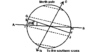
Question 0The above diagram shows the position of the Earth in relation to the sun on June 21st. The earth's axis is inclined from the vertical at an angleA.231/2oB.451/2oC.661/2oD.721/2oE.861/2oObjective Show full explanation
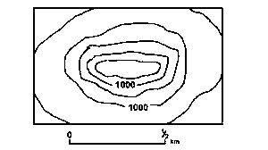
Question 0The above diagram on which the contour are in metres, shows aA.drumlinB.knollC.volcanic coneD.Block mountainE.mesaObjective Show full explanation
Question 0The ocean currents marked X and Y are theA.Cold Saharan Current and cold Namibian currentB.Warm canaries Current an dwarm Bengueka currentC.Warm gulk-stream and warm Humbolt currentD.Cool Cnaries current and cool Benguela currentE.Warm canaries current and cool mozambique currentObjective Show full explanation
Question 0What type of climate experienced in the region 'P' shaded on the mapA.Cool temperate Western MarginB.Tropical MarinaC.Tropical MonsoonD.MediterraneanE.Tropical continentalObjective Show full explanation
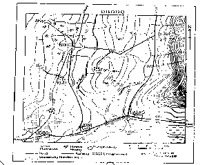
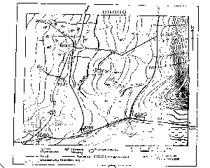
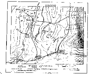
Question 0The length of the railway line shown on obodo map isA.13.75kmB.16.75kmC.19.75kmD.22.75kmE.25.75kmObjective Show full explanation
Question 0The location of the spot height(160m) east of fari near the centre of the map of obodo may be described as aA.ColB.PassC.Road gapD.WindE.SpurObjective Show full explanation
Question 0A profile drawn along M-P east of Parko - Ego road on the map describes aA.RidgeB.ScarpC.Concave slopeD.Convex slopeE.Broken ridgeObjective Show full explanation
Question 0The drainage pattern of the area shown on the map is best described asA.DendriticB.RadialC.TrellisD.RectangularE.AnnularObjective Show full explanation