Teacha
  • Courses
  • Mock Exams
  • For Tutors
  • For Schools
  • Pricing
Log InStart Free
  1. Past Questions
  2. /
  3. JAMB
  4. /
  5. Geography
  6. /
  7. 1983
  8. /
  9. Q0
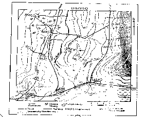
Question 0Question image

A profile drawn along M-P east of Parko - Ego road on the map describes a

  • A.Ridge
  • B.Scarp
  • C.Concave slope
  • D.Convex slope
  • E.Broken ridge
Objective

Question details

Exam body
JAMB
Subject
Geography
Year
1983
Question no.
#0
Type
Objective
Previous · Q0The location of the spot height(160m) east of fari near the centre of the map of… Next · Q0 The drainage pattern of the area shown on the map is best described as

More from this paper

  • Q0On the scale of 1: 12,500 converted to a statement scale, one centimeter would…
  • Q0If a map has a scale of 1:50,000 and oil palm plantation is represented on the…
  • Q0A map with a scale of 1:40,000 is reduced to one quarter of its size, what is…
  • Q0An international football match is scheduled to start at 4.45p.m local time in…
  • Q0Which of the following is NOT a sedimentary rock?
  • Q0A river DOES NOT erode its bed by?
See all Geography 1983 questions
Teacha

Africa's learning & exam readiness platform. Built for students, tutors, and schools.

Platform

  • Courses
  • Mock Exams
  • Past Questions

For You

  • I'm a Tutor
  • I'm a School
  • Pricing

© 2025 Teacha. Built for African learners, tutors, and schools. Teacha is not affiliated with WAEC, NECO, or JAMB. All past questions are sourced from publicly available materials.

Privacy PolicyTerms of UseCookie Policy