Teacha
  • Courses
  • Mock Exams
  • For Tutors
  • For Schools
  • Pricing
Log InStart Free
  1. Past Questions
  2. /
  3. WAEC
  4. /
  5. Geography
  6. /
  7. 2018
  8. /
  9. Q1
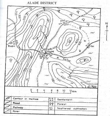
Question 1Question image

What is the scale of the map given above?

  • A.1:50,000
  • B.1 : 100,000
  • C.1 : 150,000
  • D.1 : 200,000
Objective

Question details

Exam body
WAEC
Subject
Geography
Year
2018
Question no.
#1
Type
Objective
Next · Q2 On the map above, the highest contour is

More from this paper

  • Q3Which area on the map given above can the trigonometrical station be found?
  • Q4What is the approximate length of the railway line on the map above?
  • Q5On the map above, R. Kafue takes its source from a
  • Q6The feature marked P on the map above is a
  • Q7The northern part of the map above is suitable for
  • Q8What type of settlement is ALADE from the map?
See all Geography 2018 questions
Teacha

Africa's learning & exam readiness platform. Built for students, tutors, and schools.

Platform

  • Courses
  • Mock Exams
  • Past Questions

For You

  • I'm a Tutor
  • I'm a School
  • Pricing

© 2025 Teacha. Built for African learners, tutors, and schools. Teacha is not affiliated with WAEC, NECO, or JAMB. All past questions are sourced from publicly available materials.

Privacy PolicyTerms of UseCookie Policy